
Creek Fire North Zone Update for October 5 2020
Creek Fire North Zone Update for October 5 2020
Related Incident:
Publication Type: News
Incident Start Date: 09/04/2020 Incident Start Time: 6:33 p.m.
Incident Type: Wildland Fire Cause: Under Investigation
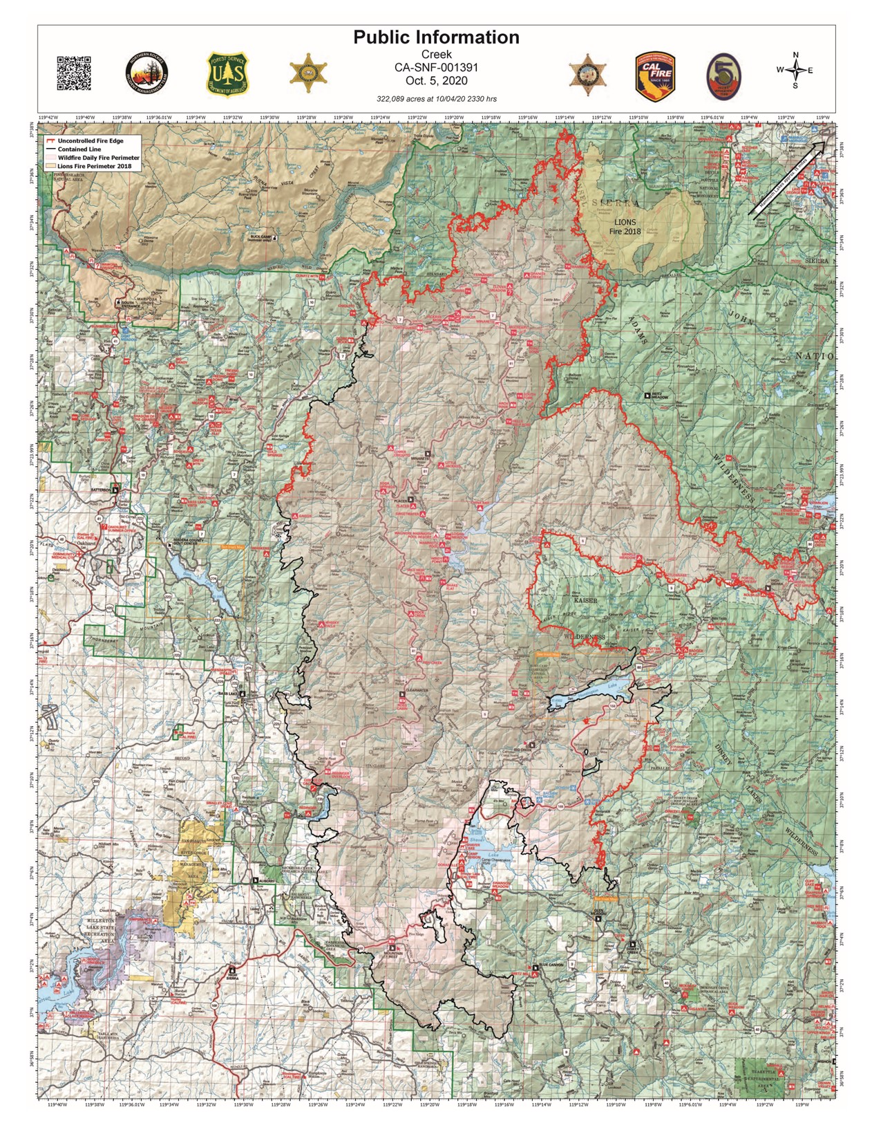
Incident Location: Both sides of the San Joaquin River near Mammoth Pool, Shaver Lake, Big Creek and
Huntington Lake.
Forest/CAL FIRE Units: Sierra National Forest, CAL FIRE Units Fresno-Kings and Madera-Mariposa-Merced
Unified Command Agencies: Northern Rockies Team 4, CAL FIRE, California Team 5, Fresno and Madera County Sheriffs
Size: 322,089 Containment: 48%
Firefighter Injuries/Fatalities: 12 injuries Expected Full Containment: 10/31/2020
Structures Threatened: 119 Structures Destroyed: 856* Structures Damaged: 71*
CURRENT SITUATION
Temporary Entry Permits: The Sierra National Forest will allow individuals who were evacuated from campgrounds, camping areas and cabins in the South Zone of the fire an opportunity to return and collect their belongings again next weekend, October 10th and 11th. Additional dates and northern access will be added as permit requests dictate. Please follow this link for more information on how to obtain an access permit. Permit Holder Access/Recreation Residence Weather Information: Transitioning high pressure will again provide a warm and dry, but stable fire environment. A steady cooling trend of 1-2° each day will continue through this week. However, temperatures will still be above average through early next week before lowering to more seasonal temperatures by midweek. Diurnal winds and low humidity will keep hot spots alive which could be fanned into a short flare up, especially in areas of higher elevation where smoke clears off during the day. Smoke transport will follow diurnal winds, upslope transport during the afternoon with smoke returning to lower elevations, downslope and down drainage flows overnight. Thermal belts will set up once again tonight with very poor humidity recovery.
Fresno County-SOUTH ZONE: Expect slow, steady, active fire spread in any direction with good fuel Continuity. Deep seated fire in heavy fuels will advance through moderate to high intensity surface fire. Very steep terrain will support short aggressive runs through timber. Zones around Florence Lake have been identified for evacuation orders. Madera County-NORTH ZONE: Along the area of uncontained fire perimeter near Cold Springs and in close proximity to Little Shuteye Peak, firefighters are attacking the slow-moving flame front directly. All other lines along the west flank, south of Globe Rock are in patrol status. Good containment has been achieved along northern fire perimeters in the vicinity Red Top Peak where active gridding (fire fighters moving through the area ensuring embers in the duff located and extinguished) and mop up are ongoing. Resources in the interior of the fire, including The Road Group continued to drop hazard trees (snagging) and clear roads of debris, as well as maintain a watch over unburned fuels in Arnold and Johnson Meadows. The last structure assessments are also taking place in the northern interior.* Seasonal and fire-induced loss of needles and leaves provides an additional opportunity for reignition within already burned areas. Crews are assessing and clearing the lines of these new flammable materials to ensure the fire does not move into unburned areas (green islands), and reduce the opportunity for slop overs and spots. The fire is still 10-12 miles west of Mammoth Lakes, little forward progression is occurring due to the natural barriers of rock and the Lions Fire (2018) burn scar. Conditions continue to be monitored very closely. Additional information is available via the Sierra National Forest Facebook page, or the following link: https://creek-fire-preparednessmonomammoth.hub.arcgis.com Cattle in and around the fire area are being rounded up and moved. Be aware of cattle, those working with them, fire personnel and other hazardous conditions when returning to the fire impacted area once it re-opens. Please respect the Temporary Flight Restriction. The use of drones is not permitted over the fire area. A drone incursion will result in the grounding of all firefighting aircraft. Remember, "If you fly - We can't."
Evacuation
Map: The evacuation map of Creek Fire evacuations for Fresno and Madera counties is available online: https://nifc.maps.arcgis.com/apps/webappviewer/index.html?id=28ce52cb86bf49dea0adef5a78b3c1b5
Incident Briefing: The Sierra National Forest will host an Incident Briefing Monday at 7pm via Facebook Live: https://www.facebook.com/SierraNF/
Damage Inspection: * Damage assessments are about 98% complete. Fresno County and Madera County: An interactive damage assessment map for Fresno County and Madera County is available: Fresno County Damage Assessment Map or https://bit.ly/3kxDyvI
Sign Up for Emergency Alerts Fresno County: https://t.co/Otack9NyKc?amp=1 Madera County: mcalert.org Mariposa County: Sheriff Office, sign up with Everbridge: msoalert.com Temporary Flight Restriction: Perimeter runs from South Merced River Fork on the south end of Yosemite National Park, south to Millerton Lake roughly following Route 41, east to Kings Canyon National Park, and north to Inyo National Forest. See: tfr.faa.gov
Evacuation Warnings: Madera County: For a complete list of evacuation warnings, see the Sheriff’s website (QR code and complete web address in yellow highlight).
Road Closures: Fresno County: Highway 168 at Kaiser Pass will be closed today, Sunday, October 4th. Madera County: Cascadel Road at 8S09 Cascadel Rd, Mammoth Road at 59701 Mammoth Road, Beasore Road at Road 274, Road 274 at Central Camp Road, and Road 632 at Buckskin Lane. Closure updates are listed at: https://www.facebook.com/MaderaSheriff/.
Temporary Evacuation Points: Fresno County Clovis North High School - 2770 East International Ave. Clovis, CA
Animal Evacuation Centers: Fresno County Small animals – Clovis North 2770 East International Ave. Large animals – The Fresno Fairgrounds, 1121 S Chance Ave, Fresno, CA 93702, is set up to receive evacuated animals but please contact the Central California Animal Disaster Team (888-402-2238) to make arrangements so animals can be received at the fairgrounds. Madera County Small animals – Oakhurst Community Center 39800 Road 425B Oakhurst, CA Large animals – Producer’s Livestock Facility at Madera Farm Bureau, 1022 South Pine Street, Madera, CA
Missing Persons: Fresno County Sheriff 559-600-3111 Madera County Sheriff 559-658-2555
National Park Closures: Yosemite National Park reopened September 25, 2020. For specific park information please visit National Park Service – Yosemite.
National Forest Closures: Effective October 3, 2020, the Sierra National Forest will be fully closed under Forest Closure Order No. 05-15-00-20-15 through November 1, 2020. Conditions will be re-evaluated daily. For information, please go to the Sierra National Forest website at: fs.usda.gov/alerts/sierra/alerts-notices
Bullfrog Fire Information: The Bullfrog Fire is burning on the Sierra National Forest but is not related to the Creek Fire. For information about that fire, please check InciWeb: Sierra National Forest Bullfrog Fire
ASSIGNED RESOURCES
Engines: 173 Water Tenders: 37 Helicopters: 13 Hand Crews: 35 Dozers: 12
Masticators and Skidders: 3 Total Personnel: 2,066
Air Tankers: Available as needed and conditions allow.
Cooperating Agencies
North Zone: Madera County, Madera County Public Health, Madera County Fire, OES, CHP, National Park Service,
PG&E, CDCR, Sothern California Edison, American Red Cross, California National Guard, California Army National Guard,
US Marine Corps of the 7th Engineering Support Battalion and US Navy (medics), Caltrans, and California Conservation
Corps.
South Zone: Fresno County, Fresno County Public Health, Fresno County OES, OES, Shaver Lake Fire Department, Bald
Mountain Fire Protection District, Auberry Fire Department, Huntington Lake Volunteer Fire Department, Big Creek
Volunteer Fire Department, Pine Ridge Volunteer Fire Department, CHP, National Park Service, CDCR, PG&E, Sothern
California Edison, American Red Cross, California National Guard, California Air National Guard, Caltrans, AT&T, US
Marine Corps of the 7th Engineering Support Battalion w/US Navy (medics) and California Conservation Corps.