Single Publication
Could not determine your location.
 Wildfire
 Prescribed Fire
 Burned Area
Response
Burned Area
Response Other
Other
Evacuations for Town Gulch Fire | Baker County Sheriff's Office 08-07-2024
Town Gulch
Publication Type: Announcement - 08/07/2024 - 17:45
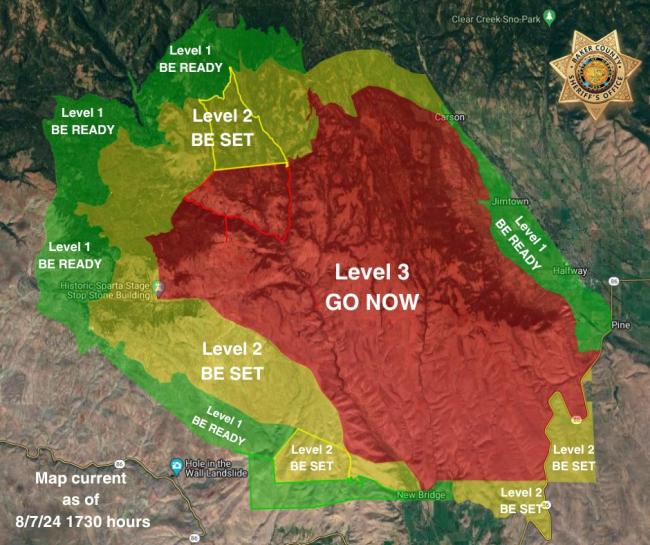
Fire activity on the Town Gulch Fire has significantly increased, prompting additional evacuations.
Level 3 (GO NOW): NEW: East of Eagle Creek Road, north of Summit Creek Road, and west of Summit Creek; this area was previously a Level 2. NEW: The northern boundary of this new area follows the line from where Shanghai Creek flows into Eagle Creek to Fizz Spring, with the other boundaries tying into existing level 3 areas; this area was previously a Level 2. South McBride Campground to Carson Creek and west of Carson Creek to Valley View Lane then west of Lee Creek to Foothill Ditch, west of Foothill Ditch to Orr Hill Lane and Lone Fir Road intersection then following along the base of the hill to Highway 86. North of Highway 86.
Level 2 (BE SET): encompasses the level 3 GO NOW zones on the northwest and south sides. South of Dempsey Creek, Basin Creek, Spring Creek, and Fuller Creek, east of Tackle Gulch and Gem Mine Road and north of New Bridge and Thorn Gulch. NEW: The area north of Carnahan Lane and above the Tobin Ditch, north of the rock pit to Immigrant Gulch to Hwy 86. This area is located on the southeast portion of the map.
Level 1 (BE READY): From Carson near the Cornucopia Highway and Allstead Lane intersection, west of the Cornucopia Highway, South Main Street, Highway 12 to the Halfway Spur, and Highway 86 to the base of the west wall. And south of the 7725 and 77 Road intersection, east of the 70 Road (continuing down to the Idaho Power powerlines), north of the powerlines to Skin Gulch, then north of Carnahan Lane ending near Summit Creek.