
Single Publication
Could not determine your location.
 Wildfire
 Prescribed Fire
 Burned Area
Response
Burned Area
Response Other
Other
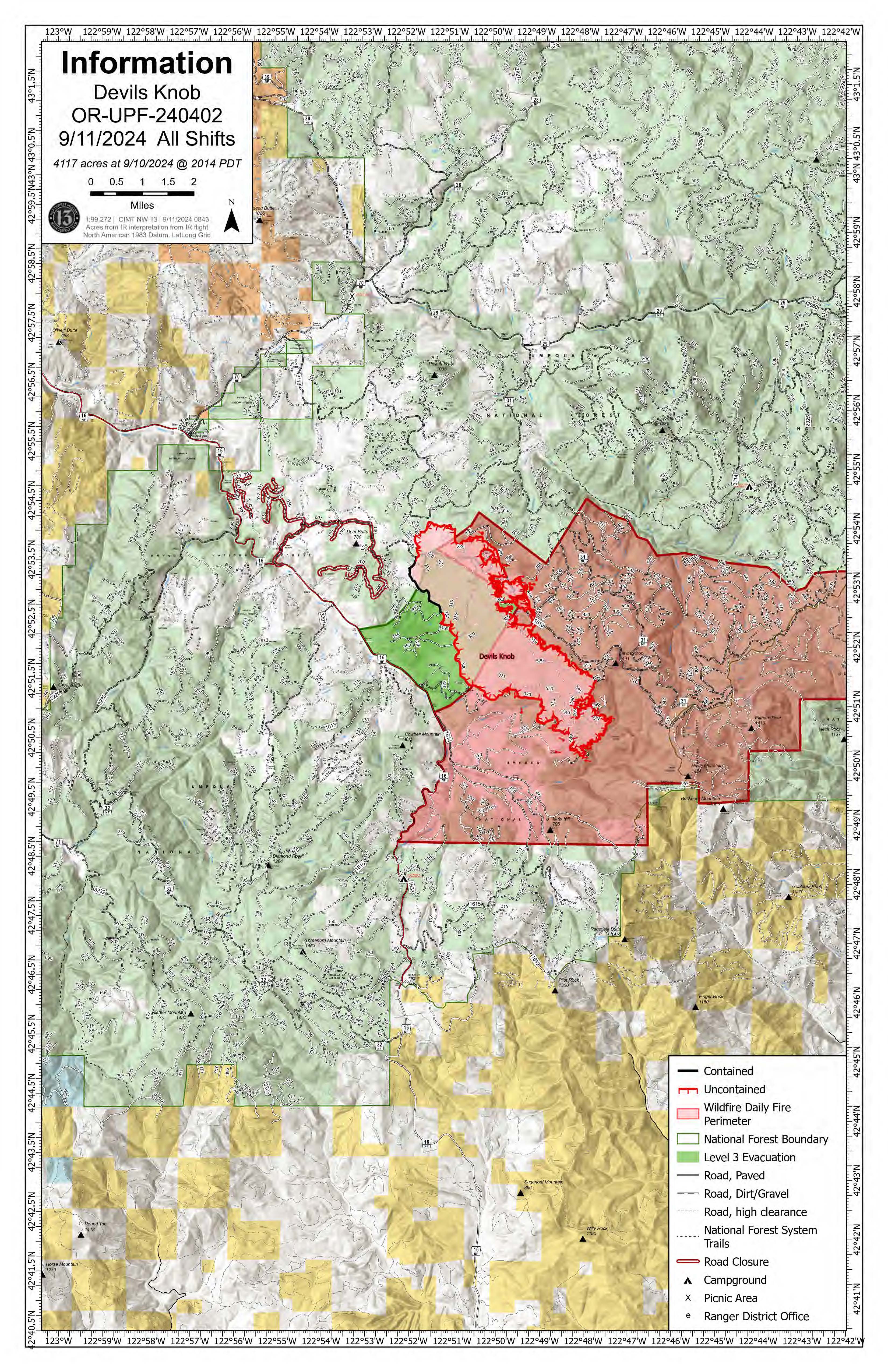
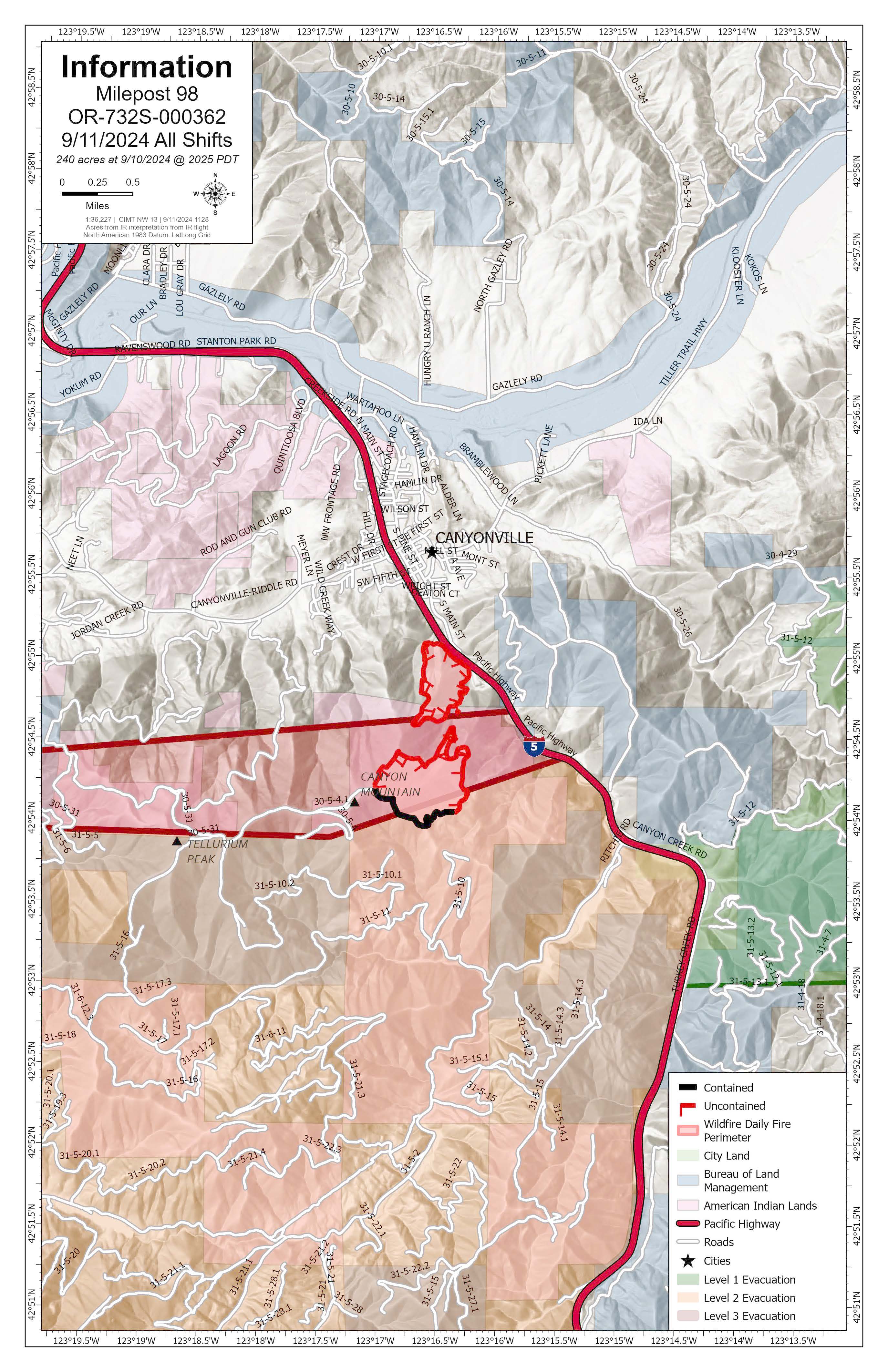
Devil's Knob and Milepost 98 Fires Morning Update 09-11-2024
Devils Knob and Milepost 98 Fires
Publication Type: News - 09/11/2024 - 09:49
Devil’s Knob and Milepost 98 Fire Update for Wednesday, September 11, 2024
KEY MESSAGES:
Evacuation levels from the Douglas County Sheriff’s Office have changed. An interactive map can be found at their website, https://www.dcso.com/EVACUATIONS. Residents are encouraged to sign up for emergency notifications through Douglas County Emergency Management, found at https:// www.dcso.com/254/Emergency-Notification-System. Currently, no level 3 evacuations exist. Level 2 evacuations include all residences on Joe Hall Road, all residences on Tison Road, all residences on Elk Diamond Road, and all residences on Ritchie Road. Level 1 evacuations include all residences on the East side of Tiller Trail Hwy between the 34000 to 36760 block. Cancelled evacuation notices include all residential addresses on Canyon Creek Road.
CIMT NW 13 will hold a public meeting tonight at 7:00 p.m. at the South Umpqua Community Church; 27292 Tiller Trail Hwy, Days Creek, OR 97429. This meeting will be recorded and posted to Facebook afterward for those unable to attend.
CURRENT STATUS:
Devil’s Knob- Resources: 612 Crews: 17 Engines: 16 Water Tenders: 10
Yesterday, crews worked on mopping up the northwest corner of the fire, west of Hamlin Prairie. Direct suppression actions were successful on the spots around the Devil’s Knob perimeter. Aviation resources focused on the southeast flank of the fire around Flat Creek to allow crews to prep line as the fire backed down to the 300 Road. Incident personnel worked to protect the powerline to the south. Today, the goal is to create more depth in mop-up operations from hand and dozerline to bolster containment efforts. If weather allows, resources will also work to create direct line in the Flat Creek area.
Milepost 98- Resources: 337 Crews: 13 Engines: 13 Water Tenders: 13
In the interior of the fire, a 30-acre island remains unburned. On the eastern edge of the fire, about a mile northwest of Ritchie Road, crews and equipment are working to complete a section of critical dozerline. Direct suppression action will be focused on the southeast corner of the fire as the western flank is being mopped up.
WEATHER / FIRE BEHAVIOR:
A cold front will bring moisture to the fire area today, with potential of a half inch to an inch of rain and gusty winds. There will also be a 20-30% chance of thunderstorms. A drying trend will start Thursday, but more moisture is expected toward the end of the weekend. Minimal fire growth is expected for both fires due to increased relative humidity.
SAFETY AND CLOSURES:
There are two closures impacting every district of the Umpqua National Forest, including a new closure for the Devil’s Knob Fire. These can be found at https://www.fs.usda.gov/alerts/umpqua/alerts-notices. While all lanes on I-5 are open between Milepost 97 and 98, the right shoulder remains closed for firefighter safety. Please use extra caution when driving due to the wet weather, which also includes increased potential for rollout debris in areas impacted by wildfire.