
Single Publication
Could not determine your location.
 Wildfire
 Prescribed Fire
 Burned Area
Response
Burned Area
Response Other
Other
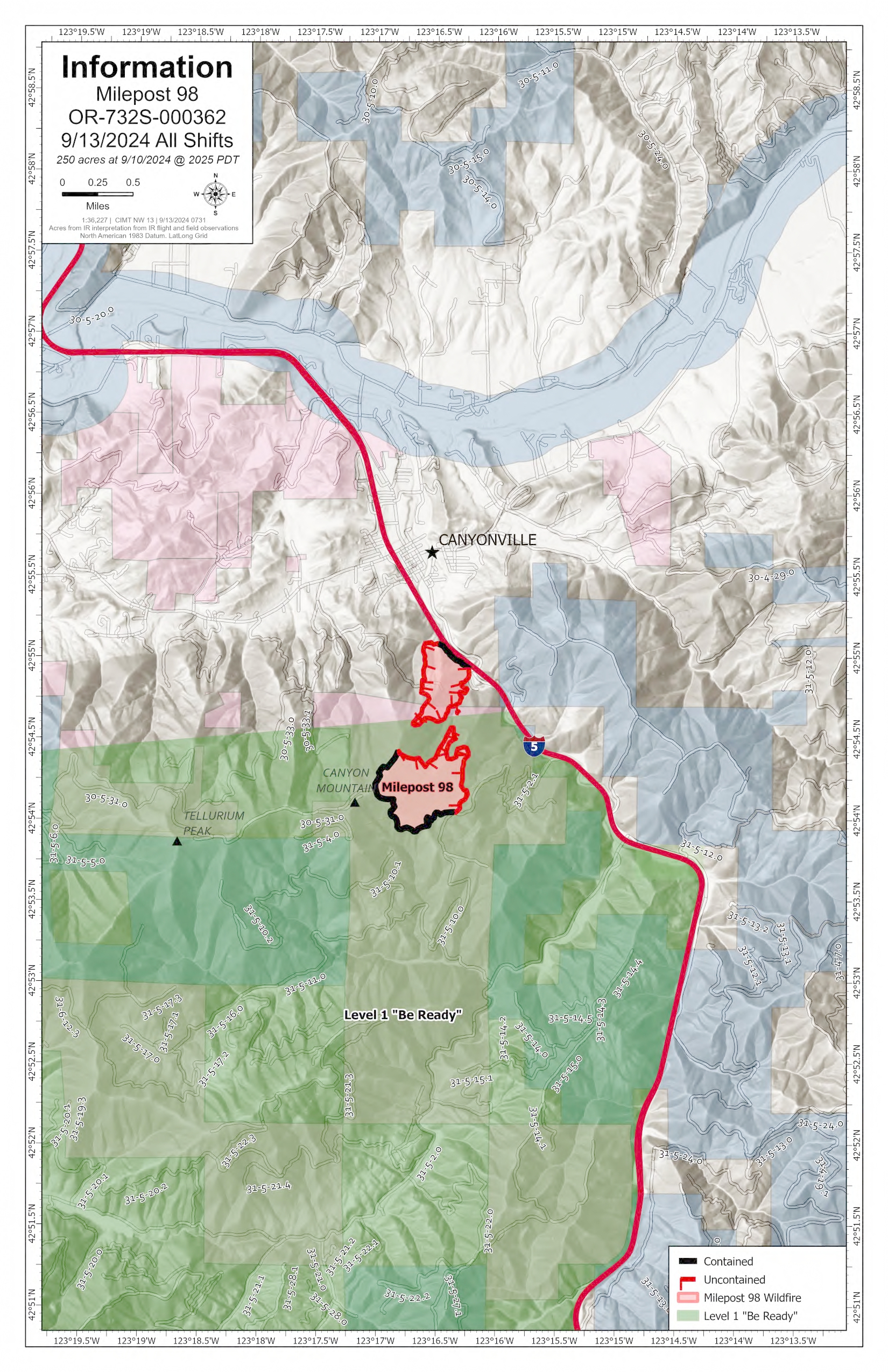
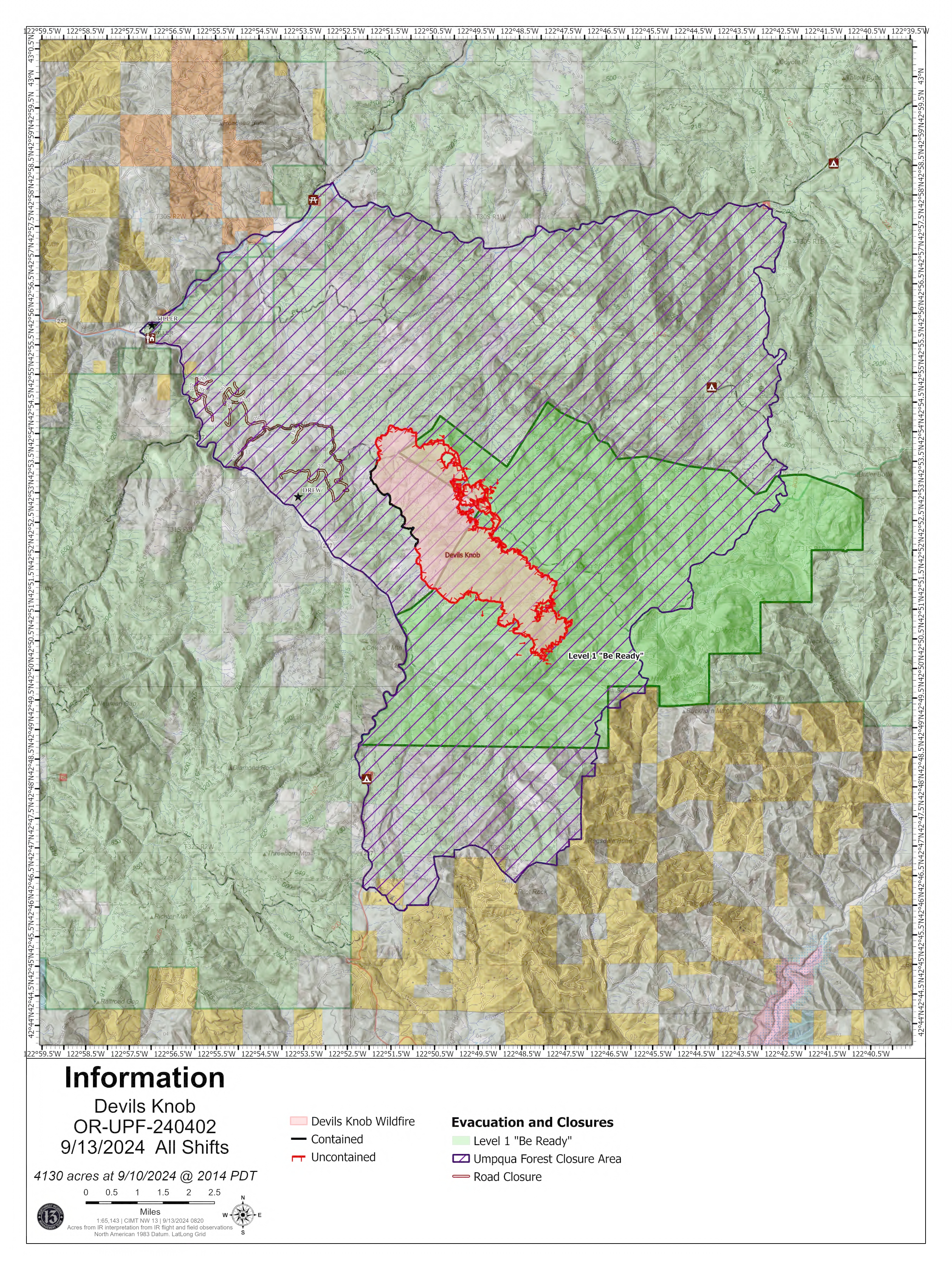
Devil's Knob and Milepost 98 Daily Update 09-13-2024
Devils Knob and Milepost 98 Fires
Publication Type: News - 09/13/2024 - 09:04
Devil’s Knob and Milepost 98 Fire Update for Friday, September 13, 2024
KEY MESSAGES:
The Douglas County Sheriff's Office has downgraded several evacuation levels for the Devil's Knob and Milepost 98 Fires. An interactive map reflecting these evacuation levels can be found online at www.dcso.com/evacuations. Currently, no Level 3 (GO NOW) or Level 2 (BE SET) evacuation notices exist for either incident. Level 1 (BE READY) evacuation notices apply to all residences on Joe Hall Road, Tison Road, Elk Diamond Road, and Ritchie Road. Residents who have been placed on any level of evacuation notice and those living in proximity of the fires should continue to monitor official sources for updated information. Any changes to these evacuation notices will be communicated through official channels.
Due to decreased fire activity, only one update will be posted daily.
CURRENT STATUS:
Devil’s Knob- Resources: 673, Crews: 19, Engines: 16, Water Tenders: 11
Mop-up and patrol operations continue around the fire perimeter. On the eastern flank, crews continue snagging operations to reduce hazard trees and plan to begin tethered dozer operations in steep terrain. Along the southern flank, heavy equipment is being put in place to continue securing the fire’s edge in the Flat Creek area.
Milepost 98- Resources: 288, Crews: 11, Engines: 12, Water Tenders: 8
Firefighters continue reinforcing fire lines and conducting mop-up and patrol operations around the perimeter. Tree fallers are engaged in snagging operations to remove hazard trees that may have been damaged in the fire and have the potential to fall. Roads in the area are being assessed for transition back to the local unit.
WEATHER / FIRE BEHAVIOR:
Yesterday was another damp day, which reduced fire behavior with cool temperatures predominantly in the 50s, relatively light winds and clearing skies in the afternoon. Dry, warmer weather returns today and tomorrow, with additional rain anticipated early next week. These conditions continue to moderate fire activity throughout the area.
SAFETY AND CLOSURES:
Closures on the Umpqua National Forest can be found at https://www.fs.usda.gov/alerts/umpqua/alerts-notices. Additionally, Umpqua National Forest remains in High Fire Danger, Public Use Restrictions Level 2, and Industrial Fire Precaution Level 2. For more information on fire restrictions, visit https://www.fs.usda.gov/main/umpqua/fire.
Fire Restrictions for Bureau of Land Management can be found on the Oregon-Washington blm.gov page.
Oregon Department of Forestry restrictions can be found at https://www.oregon.gov/odf/fire/pages/restrictions.aspx.
Douglas Forest Protective Association restrictions can be found at https://www.dfpa.net/public-fire-restrictions.