
Single Publication
Could not determine your location.
 Wildfire
 Prescribed Fire
 Burned Area
Response
Burned Area
Response Other
Other
Brice Creek, Dinner, and Grizzly Fires (Umqua NF) Emergency Closure Order
Brice Creek Fire, Dinner Fire, Grizzly Fire
Publication Type: Closures 09/20/2023
Date(s): Aug 28, 2023 - Dec 1, 2023
Forest Order: ORDER NO. 06-15-00-23-475 EMERGENCY FIRE CLOSURE
UNITED STATES DEPARTMENT OF AGRICULTURE
FOREST SERVICE
UMPQUA NATIONAL FOREST
Roseburg, OR
ORDER NO. 06-15-00-23-475
EMERGENCY FIRE CLOSURE
Pursuant to 16 USC § 551 and 36 CFR § 261.50 (a) and (b), and to provide for public safety, the following acts are prohibited upon roads, trails, and general forest areas within the Umpqua National Forest as described below and shown in Exhibit A. This Order is effective beginning August 28, 2023, and ending December 1, 2023, unless rescinded sooner.
PROHIBITIONS:
1. Being on the closed road. [36 CFR § 261.54 (e)]
2. Going into or being upon an area closed for the protection of public health and safety. [36 CFR § 261.52 (e)]
3. Being on a trail. [36 CFR § 261.55(a)]
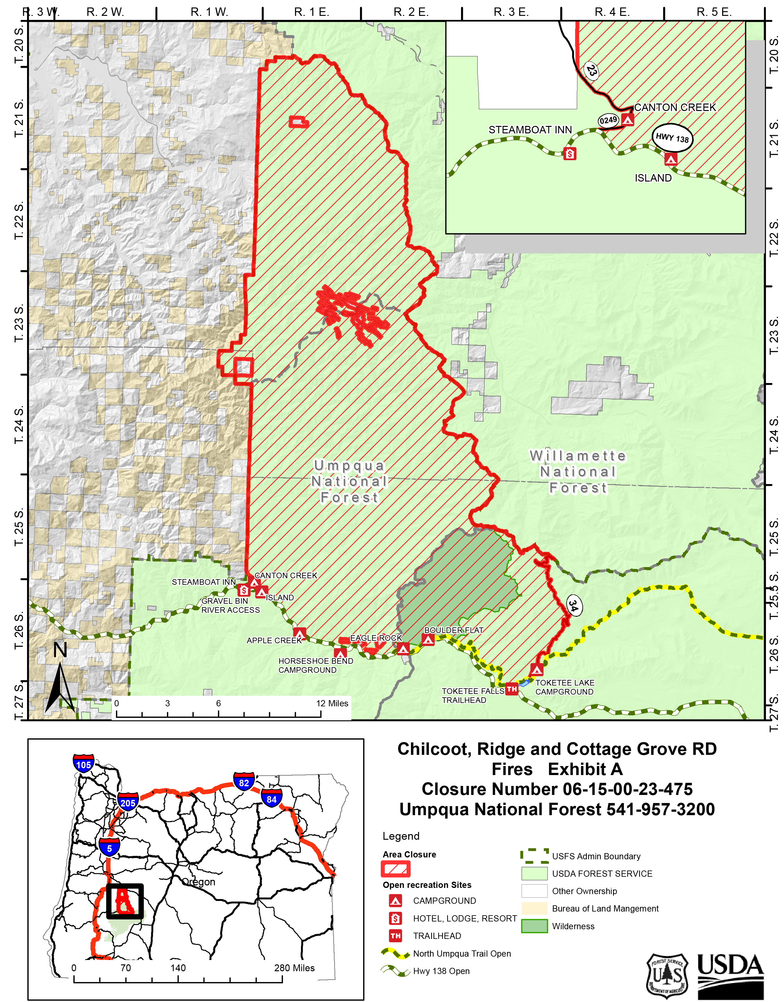
Closure Area is described as an area starting at T25½S, R1E, Sec. 32 at the junction of Forest Service Road (FSR) 38 and State Highway 138, following the southeast shoulder of Douglas County Road 0249 northeast to the intersection with FSR 23, following FSR 23 northwest to the boundary of Forest Service and private land, following that boundary north to the Forest Service proclamation boundary, following the Forest Service proclamation boundary north to the intersection of the boundary with the Willamette National Forest, then following the Umpqua National Forest and Willamette National Forest boundary east then south to the intersection with FSR 34 on the Umpqua National Forest, following FSR 34 south to the intersection of FSR 34 and Forest Service Trail (FST) 1414 (North Umpqua Trail), following the northern edge of FST 1414 to Marsters Bridge on State Highway 138, following west to the point of origin.
The following Forest Service road, trails and campgrounds are open:
• North Umpqua Trail between FSR 34 and Marsters Bridge on Highway 138
• Canton Creek Campground
• Steamboat Ballfield
• Gravel Bin Boat Ramp
• Island Campground
• Apple Creek Campground
• Horseshoe Bend Campground
• Eagle Rock Campground
• Boulder Flat Campground and Boat Ramp
• Toketee Lake Campground
• Forest Service Trail #1495, Toketee Falls trail and trailhead
EXEMPTIONS: Pursuant to 36 CFR § 261.50(e), the following persons are exempt from this order: 1. Persons with Forest Service Permit No. FS-7700-48 (permit for Use of Roads, Trails, or Areas Restricted by Regulation or Order), specifically exempting them from this order.
2. Any Federal, State, or local officer, or member of any organized rescue or fire fighting force in the performance of an official duty.
These prohibitions are in addition to the general prohibitions in 36 C.F.R. Part 261, Subpart A.
Violation of these prohibitions are punishable by a fine of not more than $5,000 for an individual or $10,000 for an organization, or imprisonment for not more than 6 months, or both (16 U.S.C. § 551; 18 U.S.C. §§ 3351, 3559, 3571, and 3581).
Executed on August 28, 2023.
Alice Carlton Forest Supervisor Umpqua National Forest