Single Publication
Could not determine your location.
Red Rock and Black Eagle Fire Update 09-18-2024
Red Rock Fire, Black Eagle Fire
Publication Type: News - 09/18/2024 - 08:23
Red Rock:
The Red Rock Fire is currently 3,055 acres and is 13% contained.
On Tuesday, crews advanced the construction of a direct handline east from the 60110 road to the 60210 road. Preparations on the 60210 road are underway to position crews for a direct fire attack in the southern section once they become available. Fire spread in this area, as well as the western portion, are being closely monitored.
As part of ongoing suppression repair efforts near the Red Rock fire, road grading will continue today using a road roller. In the northern area of the fire, crews are laying hose north from the 60110 road back to the 60210 road system. This hose will support mop-up operations to reinforce containment lines.
Additionally, crews will employ various tactics to construct a direct line north from the 60110 road up to the 4th of July Creek. Fire personnel will also conduct cold trailing along the southern edge of the fire, using the back of their hands to check for residual heat near the fireline.
Black Eagle:
The Red Rock Fire is currently 6,451 acres and is 0% contained.
Yesterday, limited fire activity was observed in the higher elevations compared to the Red Rock fire. Structure assessments were conducted to verify that previously established protections remain effective if needed.
These structure protection efforts, along with suppression repair, will continue today in the area around Black Eagle Mine and extending toward Shovel Creek.
WEATHER:
On Wednesday an upper low system that was in the fire area will continue pushing east across Montana, producing mostly cloudy skies and light rain across the fires during the afternoon. Temperatures will climb to around 50°F during the afternoon, with a minimum RH of 55-65%.
FIRE BEHAVIOR:
There is still a chance that the fire areas may see some precipitation, but by the time fire crews begin working today there will have been almost 36 continuous hours of humidity values over 75%. This will dampen fire behavior, leaving heat only in the heaviest of fuels and those fuels that are sheltered. Dead and down fuels will drive fire behavior, but fire will not spread out of these due to forecasted weather conditions.
FOREST CLOSURES:
Forest Closure Order 04-13-24-017 remains in place. Closure order 04-13-24-019 has been rescinded, and Forest Closure Order 04‐13‐24‐020 is now in place. The Salmon‐Challis National Forest has reduced the Black Eagle Fire Closure. The explanation of closure order 04-13-24-020 is as follows:
Described Roads:
NFS lands, roads and trails on the Salmon-Cobalt, and North Fork Ranger Districts of the Salmon-Challis National Forest within the area bounded by the following:
Beginning at the intersection of FS Road 112 and 055 (Panther Creek Rd) to the intersection of FS Road 112 and 113. Then following FS Road 113 to its intersection with trail 029 (FS Roads 112 and 113 are closed to the public). Then following the Frank Church River of No Return Wilderness Boundary to the Golden Trout Lake Trailhead, including the Big Horn Crags Campground and crossing over into the Frank Church River of No Return Wilderness and onto the ridge to the West of Wilson Creek, then going South to Middle Fork Peak. From Middle Fork Peak to the Frank Church River of No Return Wilderness Boundary to trail 053 then running along Little Jacket Creek to Trail 051, then following Trail 051 to Birdseye Creek to Forest Road 245 at its intersection with Panther Creek road 55. Then following the western side of FS Road 55 (Panther Creek), to the intersection of FS Road 55 and 112.
The purpose of this order is to protect public health and safety during the Black Eagle/Red Rock Fire.
This Order shall be in effect from September 17, 2024, at 8:00 am until rescinded.
For more information please visit: https://www.fs.usda.gov/alerts/scnf/alerts-notices
EVACUATIONS:
Lemhi County has made changes in the evacuation zone statuses. The changes are as follows:
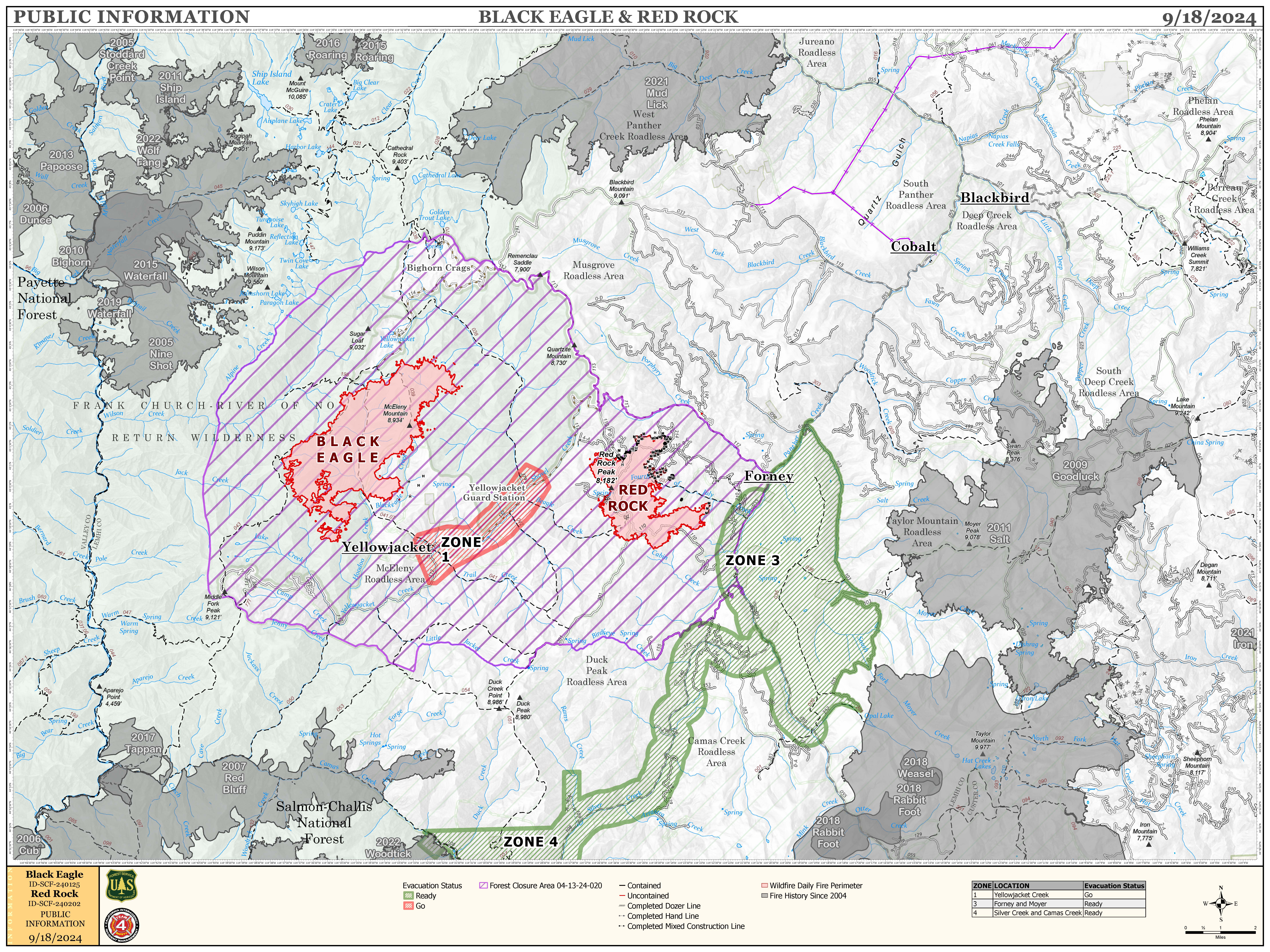
ZONE 1- WILL REMAIN IN “GO” STATUS
ZONE 2- HAS BEEN RESCINDED
ZONE 3- WILL REMAIN IN “READY” STATUS
ZONE 4- WILL REMAIN IN “READY” STATUS
Zone 1: Yellowjacket drainage
Zone 2: Cobalt to Forney
Zone 3: Forney to road #252 to road #103 and back to Moyer
Zone 4: Silver Creek, Rams Creek, and Camas Creek from Hammer Creek to White Goat Creek.

Map of Black Eagle and Red Rock Fire - 9/17/24
Map showing the locations Black Eagle and Red Rock Fires and evacuation zones.

 InciWeb