
Single Publication
Could not determine your location.
 Wildfire
 Prescribed Fire
 Burned Area
Response
Burned Area
Response Other
Other
Red Rock and Black Eagle Fire Update - 09-12-2024
Black Eagle Fire, Red Rock Fire
Publication Type: News - 09/12/2024 - 09:36
Fire Information: 208 389 4709
Hours: 8:00 AM to 8:00 PM
Email: 2024.redrock@firenet.gov
Website: https://www.fs.usda.gov/scnf/
As of 7:00 AM, California Interagency Incident Management Team 4 has taken command of the Red Rock and Black Eagle Fires.
Our primary mission on the Red Rock and Black Eagle Fires is to serve the public with dedication and compassion. With your safety and the safety of our firefighters in mind, we are committed to addressing the needs and concerns of your communities by managing and controlling the fires to keep your forests, and natural areas safe and enjoyable. Using safe and aggressive firefighting suppression methods our goal is to help you return to enjoying the outdoors.
Red Rock: Start date September 2, 2024, caused by lightening. Located approximately two miles east of Yellowjacket Guard Station on the Salmon-Cobalt Ranger District.
The fire has increased in size because of warmer weather, gusty winds, short-distance spotting, and difficult terrain. It now covers 2,570 acres and is still active. Poor visibility prevented the use of aerial resources today. Yesterday, crews worked on improving Panther Creek Road on both the east and west sides. Roads 210, 110, and 108 are being prepared as fire breaks. Today, crews will scout areas to build direct and indirect fire lines from Road 60110 south to Road 60201. They will also continue preparing Road 245 and Road 109 leading to the Ramhorn community.
Black Eagle: Start date August 5, caused by lightening. Located about 12 miles west of Forney on the North Fork Ranger District within the Frank Church River of No Return Wilderness.
The fire has now burned 5,914 acres and remains active. Poor visibility prevented the use of aerial resources today. Yesterday, crews set up multiple sprinkler systems at Yellowjacket Campground and Black Eagle Mine to protect those areas. Today, they are getting ready to install more sprinkler systems in the Crag Campground area.
WEATHER:
An upper-level weather system will stay over the fire area today, moving east and bringing more moisture to the region. This will lead to breezy westerly winds, with gusts up to 20 to 25 mph. It will also be much cooler on today. Over the next 48 hours, there’s a 60 to 70 percent chance of getting at least half an inch of rain in the fire area. If rain changes to snow, it’s expected to be light. By Friday, the weather system will move out, and it will become drier and warmer as the day goes on, with the winds becoming more stable.
FOREST CLOSURE:
NFS lands, roads and trails on the Salmon‐Cobalt, and North Fork Ranger Districts of the Salmon‐Challis National Forest within the area bounded by the following:
- Beginning at the intersection of Blackbird creek with Panther Creek, following Blackbird creek to Blackbird mountain, then following FS Road 33 to the Frank Church River of No Return Wilderness boundary, and following the boundary to the Golden Trout Lake Trailhead, including the Big Horn Crags Campground and crossing over into the Frank Church River of No Return Wilderness and onto the ridge to the west of Wilson Creek, then going south to Middle Fork Peak. From Middle Fork Peak to the Frank Church River of No Return Wilderness Boundary to trail 053 then running along Little Jacket Creek to Trail 051, then following Trail 051 to Birdseye Creek to Forest Road 245 at its intersection with Panther Creek Road 55, then following the western side of Panther Creek Road until it reaches Blackbird Creek.
- Additionally, the McDonald Creek Campground and all associated roads are closed.
For the latest information on area closures, please contact the North Fork Ranger District at (208) 865-2700.Details on the Black Eagle Fire can also be found on InciWeb: https://inciweb.wildfire.gov/incident-information/idscf-black-eagle-fire.
The forest is asking visitors to be aware of the fire danger for the Salmon-Challis National Forest. Ensure your campfire is dead out. If it is too hot to touch, it is too hot to leave! One Less Spark Means One Less Wildfire. Since June 1, Forest employees have found and extinguished at least 13 abandoned campfires.
EVACUATIONS:
Lemhi County: Evacuation order and warnings remain in effect. For more information, please go to: https://www.lemhicountyidaho.org/site-home/news/black-eagle-and-red-rock-fire-update
SMOKE REPORT:
For more information about drift and air quality, go to AirNow.gov https://outlooks.airfire.org/outlook/d60d6285.
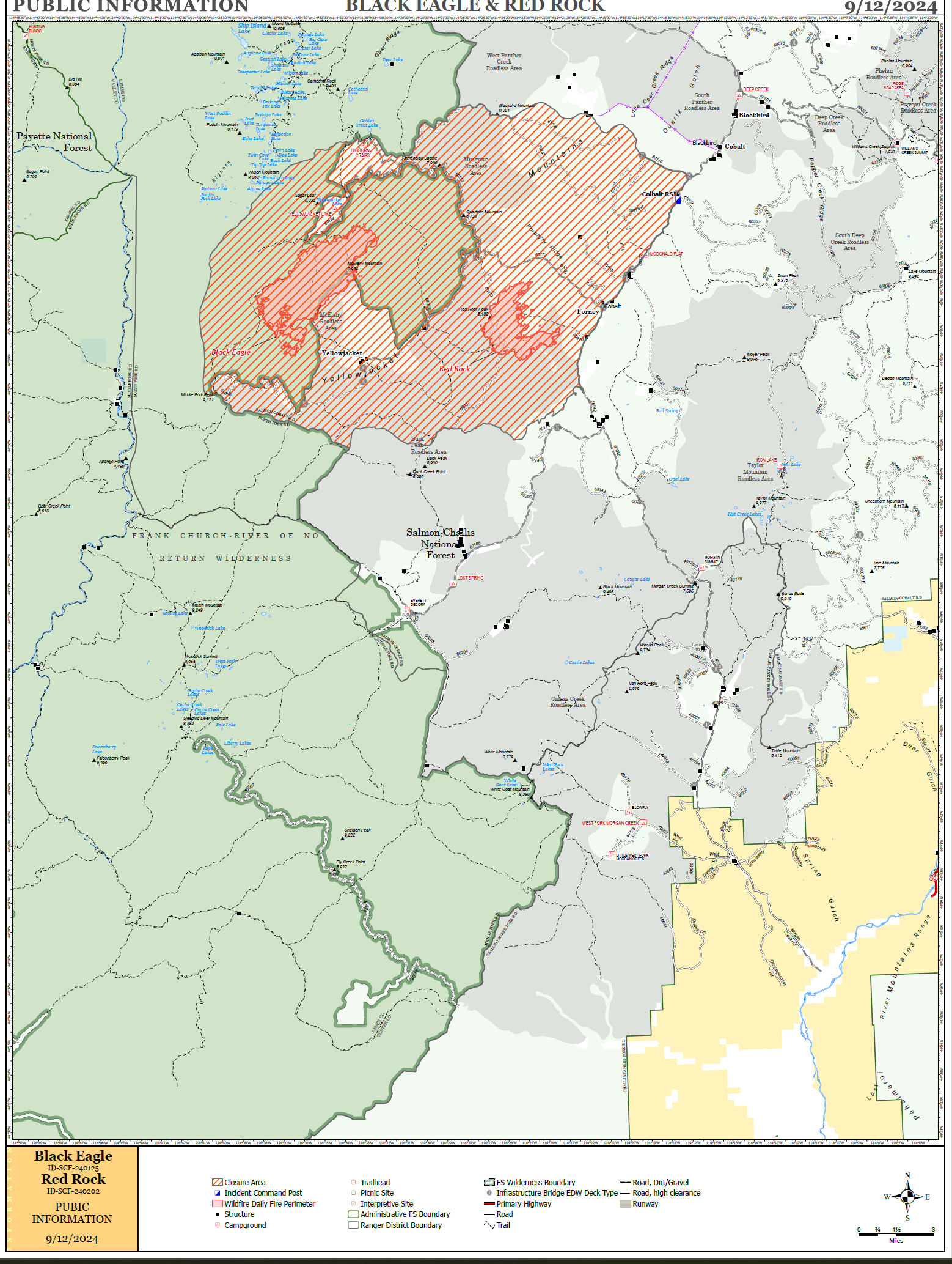
PIO map of the fires