
Single Publication
Could not determine your location.
 Wildfire
 Prescribed Fire
 Burned Area
Response
Burned Area
Response Other
Other
Moore Square Area Closure August 30, 2024 09-06-2024
Moore Square Complex
Publication Type: Closures - 09/06/2024 - 17:07
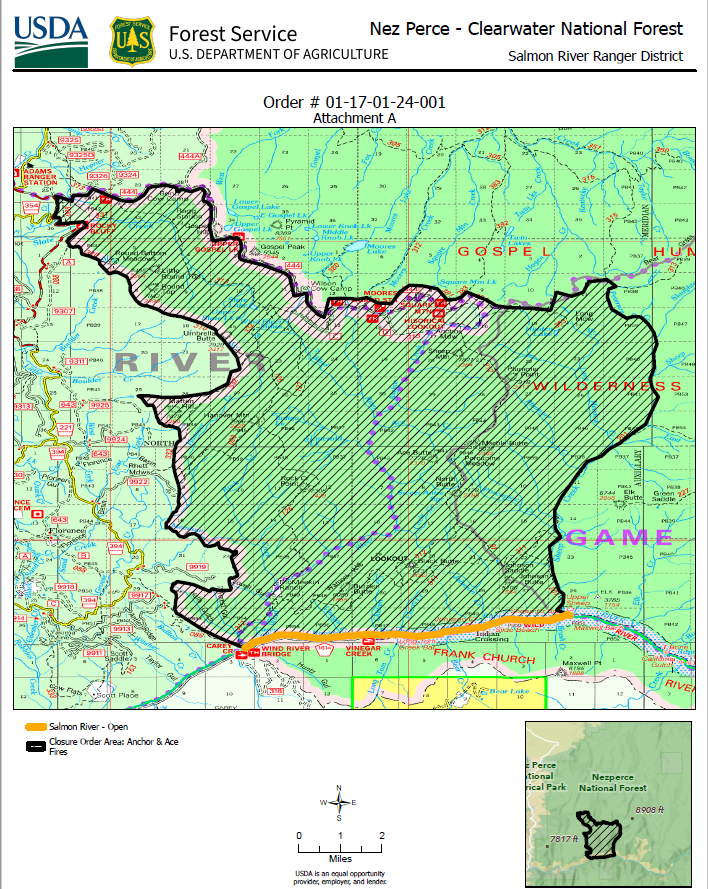
Order Number: # 01-17-01-24-001
U.S. Department of Agriculture, U.S. Forest Service
Nez Perce-Clearwater National Forest
Salmon and Red River Ranger Districts
Area, Road, Trail Closure
PROHIBITIONS
Pursuant to 16 U.S.C. § 551 and 36 C.F.R. § 261.50(a) and (b), the following are
prohibited on the National Forest System (NFS) lands, road, and trails in the Nez
Perce-Clearwater National Forests, Salmon River Ranger District and the Red Ranger
District, described below and shown on the attached map incorporated into this Order
as Exhibit A the Described Area, Roads, and Trails:
1. Going into or being in the Described Area. 36 C.F.R. § 261.52(e).
2. Being on the Described Roads. 36 C.F.R. § 261.54(e).
3. Being on the Described Trails. 36 C.F.R. § 261.55(a).
EXEMPTIONS
Pursuant to 36 C.F.R. § 261.50(e), the following persons are exempt from this Order:
1. Persons with Forest Service Permit No. FS-7700-48 (Permit for Use of
Roads, Trails, or Areas Restricted by Regulation or Order), specifically
exempting them from this Order or a written determination by a Forest
Service authorized officer that a permit is not required under 36 C.F.R. §
251.50(e)(1) or (2).
2. Owners or lessees of land in the Described Area or who need
to use the Described Roads or Trails to access land they own
or lease.
3. Any Federal, State, or local officer, or member of an organized rescue or
fire fighting force in the performance of an official duty.
4. Federal or State administrative personnel in the performance of an official
duty.
DESCRIBED AREA/ROADS/TRAILS
The Described Area is entirely within Idaho County, Idaho and includes all NFS lands
within the following boundaries:
Area Defined within: Commencing at Slate Lake Trailhead on the Southern
shoulder of FS Road 444 (also known as the point of beginning) and
proceeding west along FS Road 444 to the junction of FS Road 221. Then
proceeding South along FS Road 221 to Rocky Bluff Campground. Then
proceeding South along the Wilderness Boundary and FS Trail 310. Then
proceeding South 1 mile on FS Trail 332. Then following the Wilderness
Boundary contouring around Martin Hill proceeding South 13.7 miles to the
intersection with the centerline of the Salmon River. Then proceeding East
along the Salmon River 6.80 miles to the confluence with Sheep Creek. Then
proceeding North along Sheep Creek to its confluence with Peterson Creek.
Then Proceeding Northwest up Peterson Creek to its junction with FS Trail
313. Then proceeding West along FS Trail 313 to the junction of FS Trail 384.
Then proceeding Northwest on FS Trail 384 to the junction of FS Trail 383.
Then proceeding Southwest on FS Trail 383 to the junction of FS Road 444
Square Mountain Trailhead. Then proceeding Northwest on the Northern
shoulder of FS Road 444 to the point of beginning.
FS Road 444 will be closed from Slate Lake Trailhead to its terminus at Square
Mountain.
The area contained within this closure order contains 57,331 acres.
The Described Area excludes the Salmon River Wild and Scenic Corridor below the
high water line.
PURPOSE
The purpose of this Order is to protect public health and safety during an active wildfire.
IMPLEMENTATION
1. This Order shall be in effect from August 30th 2024 at 18:00 through November 1st
2024 at 18:00, unless rescinded.
2. A map identifying the Described Area, Roads and Trails is attached and made part
of this Order as Exhibit A. For a digital version of this Order and Exhibit A, go to
https://www.fs.usda.gov/alerts/nezperceclearwater/alerts-notices.
3. Unless otherwise expressly defined in this Order, the terms used in this Order are
defined by the regulations of the Secretary of Agriculture, 36 C.F.R. Chapter II,
Parts 200-299. If there are terms in this Order that are not expressly defined in the
Order or 36 C.F.R. Chapter II, Parts 200-299, their meaning shall be determined
by their plain language definitions.
4. A violation of the above prohibitions is punishable as a Class B misdemeanor by
a fine of not more than $5,000 for individuals and $10,000 for organizations, or by
imprisonment for not more than six months, or both. 16 U.S.C. § 551; 18 U.S.C.
§§ 3559, 3571, and 3581.
5. Contact the Salmon River Ranger District in White Bird, ID (208) 839-2211, or Nez
Perce-Clearwater National Forest Supervisor’s Office in Kamiah, ID, (208) 935-
2513, for more information about this Order.
6. This Order supersedes any previous Orders prohibiting the same or similar acts
on the same Described Area, Roads and Trails.
Signed and issued on August 30, 2024.
_______________________
Acting Forest Supervisor
Nez Perce-Clearwater National Forests