
Single Publication
Could not determine your location.
 Wildfire
 Prescribed Fire
 Burned Area
Response
Burned Area
Response Other
Other
Bluff Creek Complex Daily Update 08-02-2024
Bluff Creek Complex
Publication Type: News - 08/02/2024 - 17:17
Bluff Creek Complex
Idaho Panhandle National Forests
Fire Information 208-557-8813
https://inciweb.wildfire.gov/incident-information/idipf-bluff-creek-complex
August 2, 2024
Idaho Panhandle Type 3 Incident Management Team
Incident Commander Brian Hicks and Incident Commander Trainee Bryce Barth
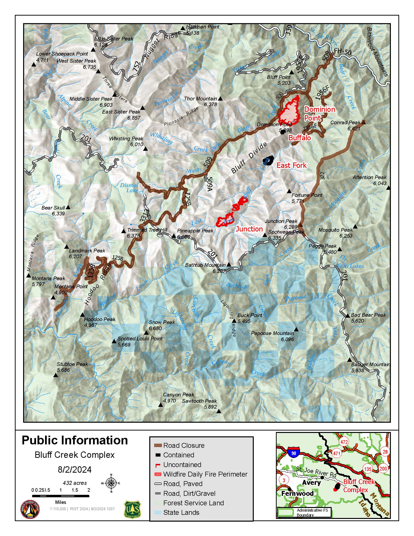
Location: The fires are burning along both sides of the Bluff Divide, approximately 13 1/2 miles southeast of Avery, ID; five and a half miles west of Gold Creek Campground; and approximately two miles northwest of Junction Ridge.
Start Date: 7/25/2024 Cause: Lightning Size: 432 acres
193 Total Personnel:
5 Engines
4 Type 2 Hand Crews
2 Interagency Hotshot Crews
6 Heavy Equipment
4 Water Tenders
Key Message:
Updates will occur when conditions warrant, such as changes in acreage or containment.
Current Status:
The Bluff Creek Complex consists of four different fires: Junction Fire, East Fork Fire, Dominion Point Fire, and Buffalo Fire. The Dominion Point Fire held at 275 acres; the Junction Fire is 60% contained and 130 acres; the East Fork Fire is 80% contained and 25 acres; and the Buffalo Fire is 100% contained at 2 acres. An infrared flight in the early hours of August 1st resulted in a reduction in acreage due to more precise mapping. All available resources are engaged in suppression, working on these fires based on priority order. Due to the threat to values at risk, including private industry timberlands, active logging sales, and equipment, the Junction Fire and the East Fork Fire remain priority, but work continues on Dominion Point as well.
Approximately 1” of rain was received across the Fire Complex on July 30th, greatly moderating fire behavior and providing an opportunity for firefighters to increase containment. Much of the fireline (constructed with hand tools, heavy equipment, or reinforced roads) is now plumbed, meaning hoses are set up to aid firefighters in holding these lines.
WEATHER
Temperatures have increased again with 96-104 degrees in the valleys and 87-97 in the mountains. Relative Humidity decreased, ranging from 16%-26%. Temperatures will stay elevated through the weekend, with possible thunderstorms on Sunday.
Closures and Special Messages
Closure orders are in place to protect the safety and welfare of the public and provide for safe firefighting efforts and access. Specific closure information and maps are posted on InciWeb at https://inciweb.wildfire.gov/incident-closures/idipf-bluff-creek-complex and https://www.fs.usda.gov/alerts/ipnf/alerts-notices as they are implemented.
The Bluff Creek Complex closures include the following roads and area:
- CLOSED:
- Order Number: # 01-04-04-24-005 (Bluff Creek Fire Road Closure)
- Forest Development Road 509 beginning at its junction with County Highway 50 and concluding at its intersection with Forest Development Road 201.
- Forest Development Road 1258 beginning at its junction with Forest Development Road 509 concluding at its intersection with Forest Development Road 201.
- Forest Service Development Road 1956F beginning at its junction with Forest Development Road 509 and concluding at its unction with Forest Development Road 3338.
- Forest Development Road 322 beginning at its junction with Forest Development Road 201 concluding at Conrad Peak.
- Order Number: # 01-04-04-24-006 (Gold Flat Area Closure): Gold Flat undeveloped campsite located 8.6 miles North on Forest Development Road 218 from Red Ives Cabin. Gold Flat undeveloped campsite is located within Section 23 and 24 in T16N, R30W. The area Gold Flat undeveloped campsite comprises approximately 6.2 acres bordered by the St. Joe River on the West and Forest Development Road 218 on the East.
- Order Number: # 01-04-04-24-005 (Bluff Creek Fire Road Closure)
At this time, a TEMPORARY FLIGHT RESTRICTION is in place for 27NM SE KELLOGG, Idaho near MULLAN PASS VOR/DME (MLP). No pilots may operate an aircraft in the areas covered, including drone pilots.