
Highlighted Activity

Daily Update | Daily Operations Videos | Daily Public Information Map | Daily Fire Progression Map | Evacuation Map | Smoke Outlook / Air Quality Report
Camera views of area/smoke impacts: NPS.gov – Air Webcams | Windy.com | ALERT California
Unified Command: SACIMT2
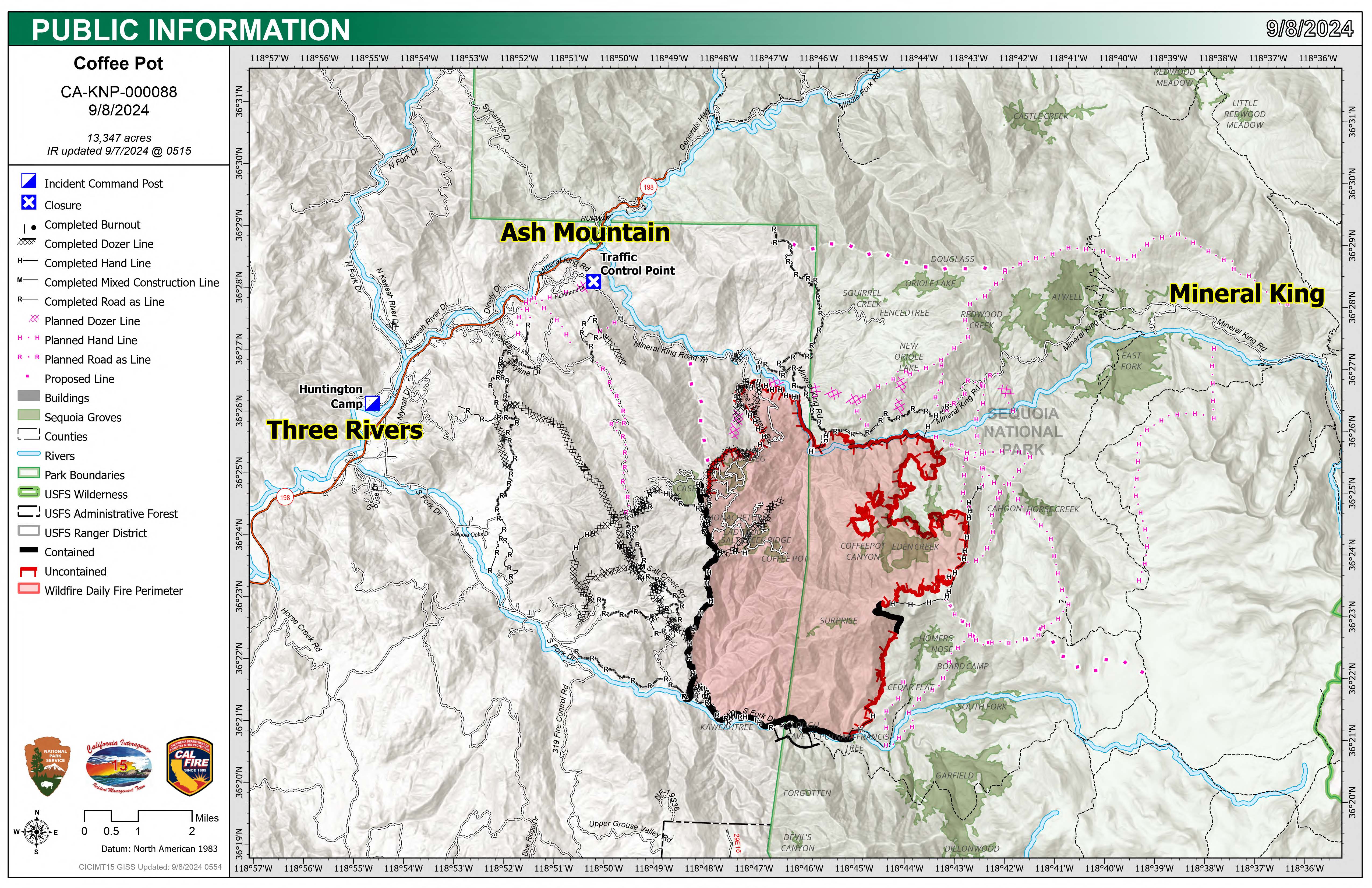
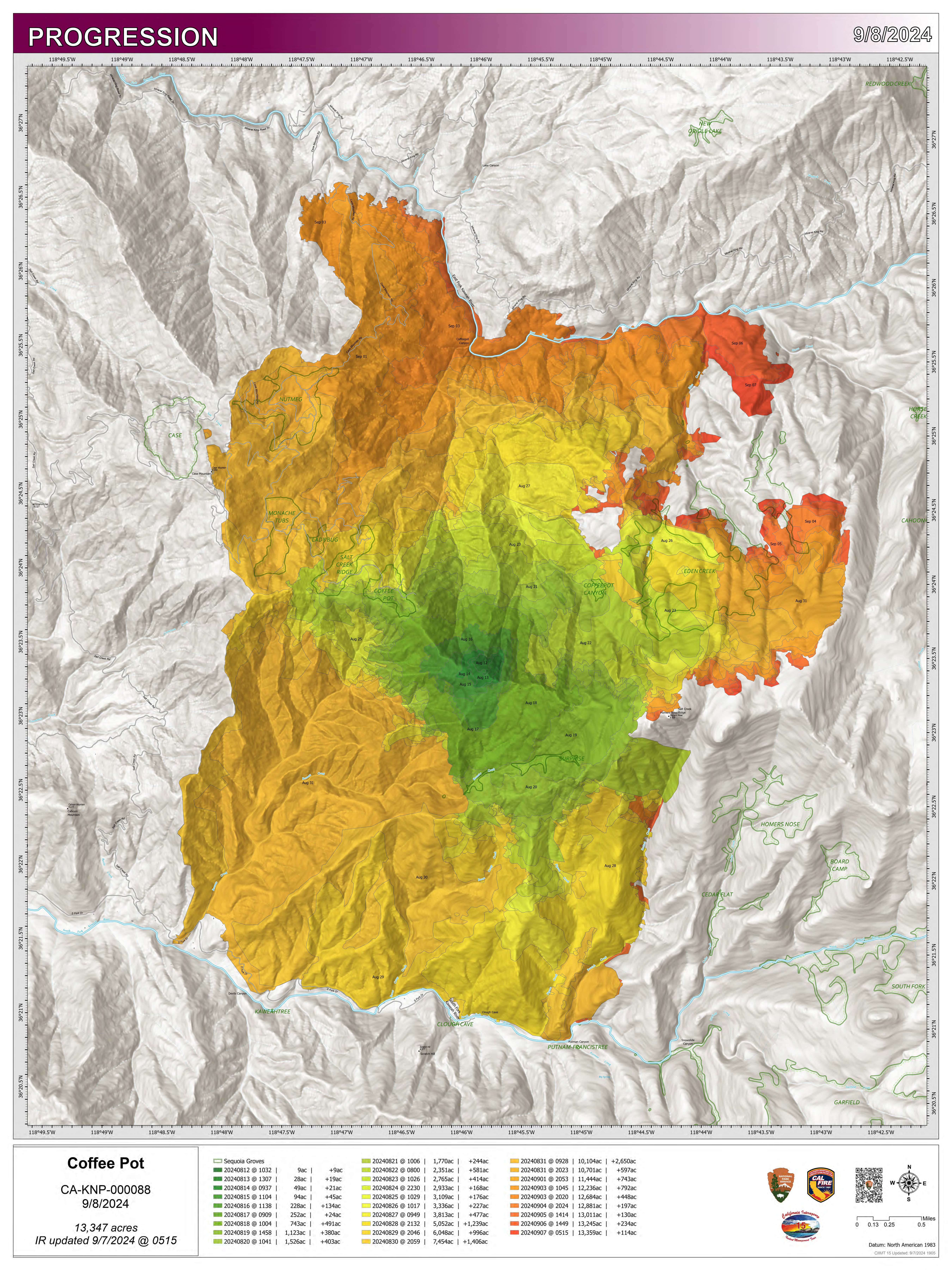
Fire Size: 14,086 acres
Percent Contained: 79%
Primary Strategic Control Line: 96%
Personnel: 637
Cause: Lightning
Start Date: Saturday, August 3, 2024, at 10:05 a.m.
Location: Southeast of Three Rivers, CA
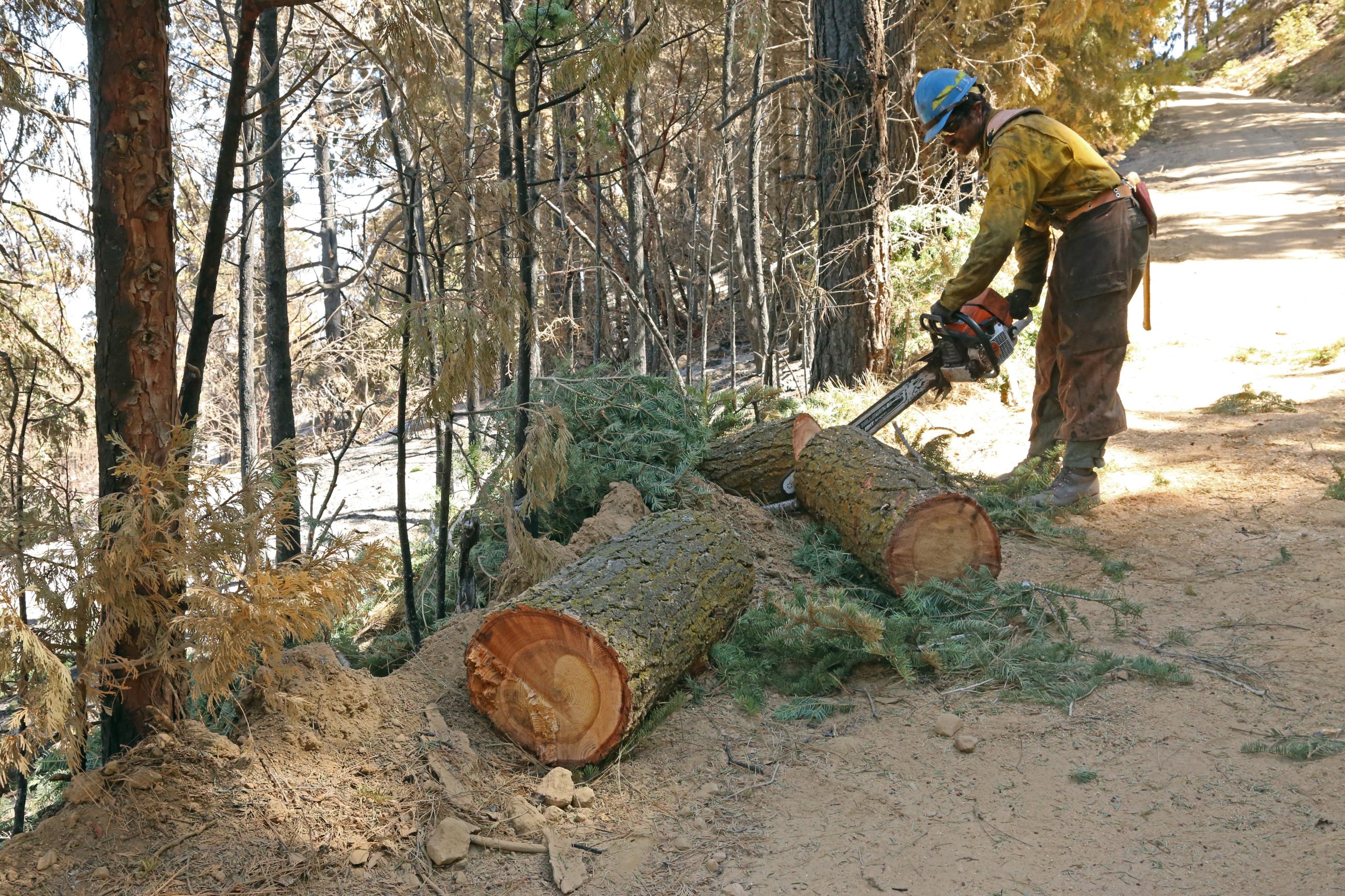
CURRENT SITUATION: Yesterday, interior unburned fuel islands continued to slowly consume and the fire remained within its current footprint. Firefighters remained engaged in the northeastern section of the fire from the East Fork Kaweah River south toward Scratch Creek reinforcing control lines. Crews worked diligently to mop up and patrol the southern and western flanks, extinguishing remaining hot spots and reducing any threats to the control line. Contingency work advanced along Mineral King Road with crews removing flammable material and hazardous trees east toward Silver City. Crews and heavy equipment completed suppression repair activities along the western control line; working to minimize soil erosion, prevent impacts to water quality, and restore pre-fire conditions as much as possible.
Today’s predicted weather conditions are expected to moderate fire behavior; lower temperatures, cloud cover, and increased humidity will make fuels less likely to burn. Crews will actively patrol the control lines and backhaul unneeded equipment from the southern and western flanks of the fire. Hotshot crews will continue strengthening control lines in the area around Homers Nose and in the Horse Creek drainage. Meanwhile, contingency work along Mineral King Road will remain ongoing.
WEATHER: A strong low-pressure system will dominate the region today plunging temperatures roughly 20 degrees below normal for this time of year. There will be a slight chance of light rain with this initial disturbance, but better chances exist later in the week. Expect the best chance for light precipitation in the late morning and early afternoon before low clouds attempt to dissipate through the afternoon hours. Snowfall will be possible above 7-8,000 feet.
SMOKE IMPACTS: With the change in weather and limited fire activity, smoke production will be lower today. Areas within the forecast will see overall GOOD air quality conditions throughout the day. Springville will be in the MODERATE range this morning due to smoke impacts from fires south of the Coffee Pot fire, but are expected to improve to GOOD by late afternoon. For more information on current wildfire smoke impacts in your community, please visit AirNow.gov or fire.airnow.gov.
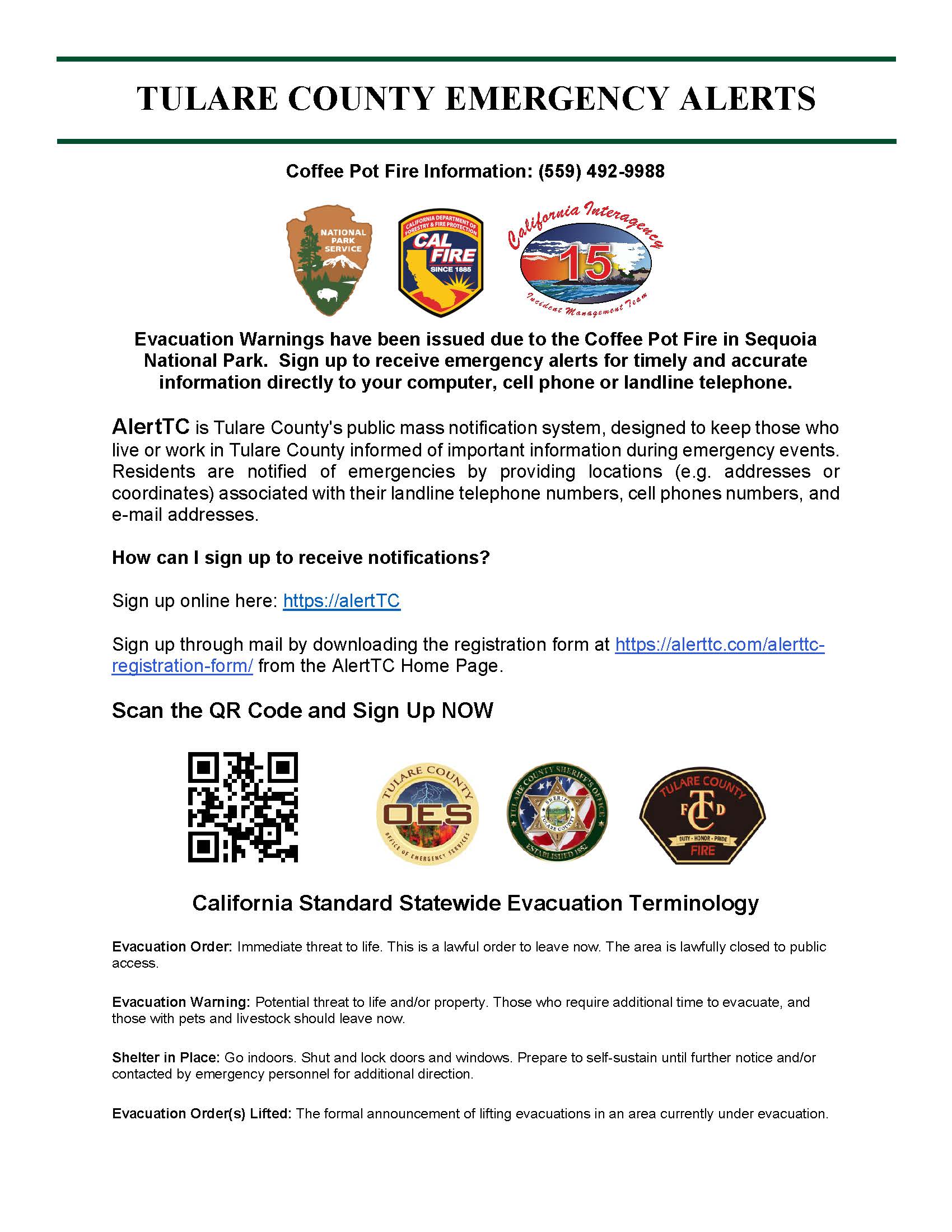
EVACUATION NOTICES: The Tulare County Fire Department has issued Evacuation WARNINGS for zones TLC-E094-B, TLC-E094-C, TLC-E094-D, TLC-E094-E, and TLC-E095. To find your zone, please refer to: protect.genasys.com.
FIRE INFORMATION: A Public Information Officer will be at the Three Rivers Village Market daily from 11:00 a.m. to 4 p.m. to provide fire information and answer questions.
BLM AND PARK CLOSURES: The portion of South Fork Drive within Sequoia and Kings Canyon National Parks and trails accessed from the road, including the Ladybug and Garfield Grove Trails, are closed. Recreational access to the Mineral King area of Sequoia National Park is closed to the public. This applies to Mineral King campgrounds, trailheads, and area trails. All other areas of the parks are open but are likely to be impacted by varying levels of smoke and poor air quality. Park closure information is available online at nps.gov/seki. The Bureau of Land Management has also issued a closure of the Case Mountain Extensive Recreation Management Area at blm.gov/press-release.
PUBLIC NOTICE: Wildfires are a no-fly zone for unauthorized aircraft, including drones. If you fly, we can’t. For more information, visit knowbeforeyoufly.org.
| Current as of | Mon, 09/16/2024 - 13:15 |
|---|---|
| Incident Time Zone | America/Los_Angeles |
| Incident Type | Wildfire |
| Cause | Lightning/Natural |
| Date of Origin | |
| Location | Southeast of Three Rivers, CA |
| Incident Commander | Southern Area Complex Incident Management Team #2 Andy Baker, Cody Bogan, Jon Wallace (T) |
| Coordinates |
36° 23' 29.88'' Latitude
-118° 45' 53.34
'' Longitude
|
| Total Personnel: | 637 |
|---|---|
| Size | 14,086 Acres |
| Percent of Perimeter Contained | 79% |
| Fuels Involved | Timber (Liter and Understory) Fire is burning in a wide range of fuel types due to over 6000 feet of elevation gain from the bottom to the upper portions of the fire areas. Fuels include timber model (TU5) with heavy understory and some small pockets of timber litter. Fuels transition from timber with bug kill and dead and down into overhead brush at elevations below 5000 feet. Fuels transition again to oak woodland with scattered scrub oak and grass understory at the lower elevations. 1000- hour fuels are available to burn with fuel moisture measured between 4%-10% depending on aspect and elevation. Live fuel moisture in Manzanita was measured at 100% at upper elevations and 90% at the lower elevations. Chamise samples on the lowest elevations have been sampled at 66%. |
| Significant Events | Moderate, Flanking, Backing & Creeping The majority of fire behavior is moderate with rollout, backing, and flanking in most areas. As crews work to complete direct line from the ridge east of Horse Creek down to the creek to contain a prior slop over, afternoon winds and rollout potential will challenge containment lines along the eastern and northeastern flank. |
| Planned Actions |
Continue to patrol and increase depth on mop-up on all containment lines. Keep the fire south of the East Fork of the Kaweah River. Strengthen retardant line on Horse Creek with hand line to keep the fire in the current footprint north of Horse Creek. Continue brushing on Mineral King Road while scouting ridgelines located east of the current fire perimeter. Work with READS/REAFS to mitigate hot spots within Sequoia Groves. Assess structures in the Mineral King and Silver City areas for structure defense. Continue suppression repair in areas approved by READS/REAFS. |
|---|---|
| Projected Incident Activity |
12 hours: As a low-pressure system moves through the area, cooler temperatures and higher relative humidity will help moderate fire activity. The majority of fire behavior will be moderate to minimal with rollout, backing, and flanking in most areas. Afternoon winds will challenge containment lines along the eastern flank from Homers Nose to the junction between Horse Creek and East Fork Kaweah River, as well as the slop over across Horse Creek to the ridge above and east of it. Late afternoons see an uptick in activity with peak drying, afternoon winds, and fire spread especially along the East Fork Kaweah River, and potential still exists for spotting across the river and uphill runs impacting Mineral King Road, or for additional fire movement south of the East Fork Kaweah beyond the ridge east of Horse Creek. 24 hours: Temperatures expected to fall several degrees below normal. Cooler temperatures and higher relative humidity will help moderate fire activity. Continued spotting potential with consumption of heavy fuels interior above the East Fork Kaweah River at its confluence with Horse Creek. East Fork Kaweah River may hold fire spread in some areas, but the threat remains for fire crossing the river and making slope aligned runs up towards Mineral King Road, particularly East of Lookout Point. Fuels will be lighter as they are within the KNP Complex fire scar, but may be a challenge for ground resources. Anticipate potential challenges to the retardant check lines in and above Horse Creek from rollout and the recent slop over on the east side of Horse Creek at its confluence with the East Fork Kaweah. Anticipate potential movement to the East with any slope and wind alignment on granite patches north of Homers Nose, threatening movement into the Unnamed Creek and Cahoon Creek to the east. |
| Remarks |
Southern Area CIMT #2 took command of the incident at 0700 today. |
| Weather Concerns | Synopsis: Observed: |
|---|