
Highlighted Media
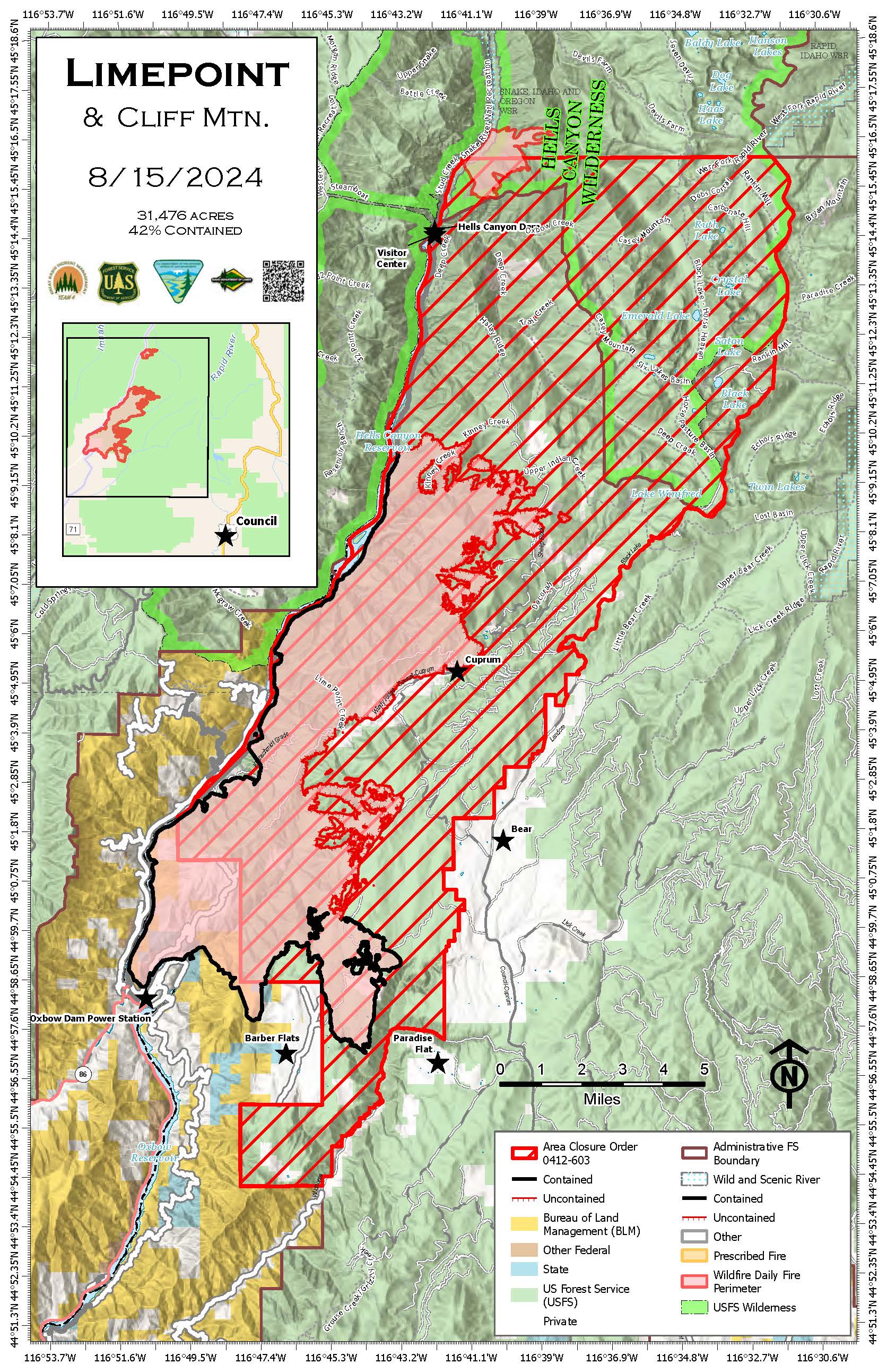
Cliff Mountain Fire Map, August 15, 2024
On Friday, August 16, 2024, the Cliff Mountain Fire transitioned back to the Wallowa Whitman National Forest.
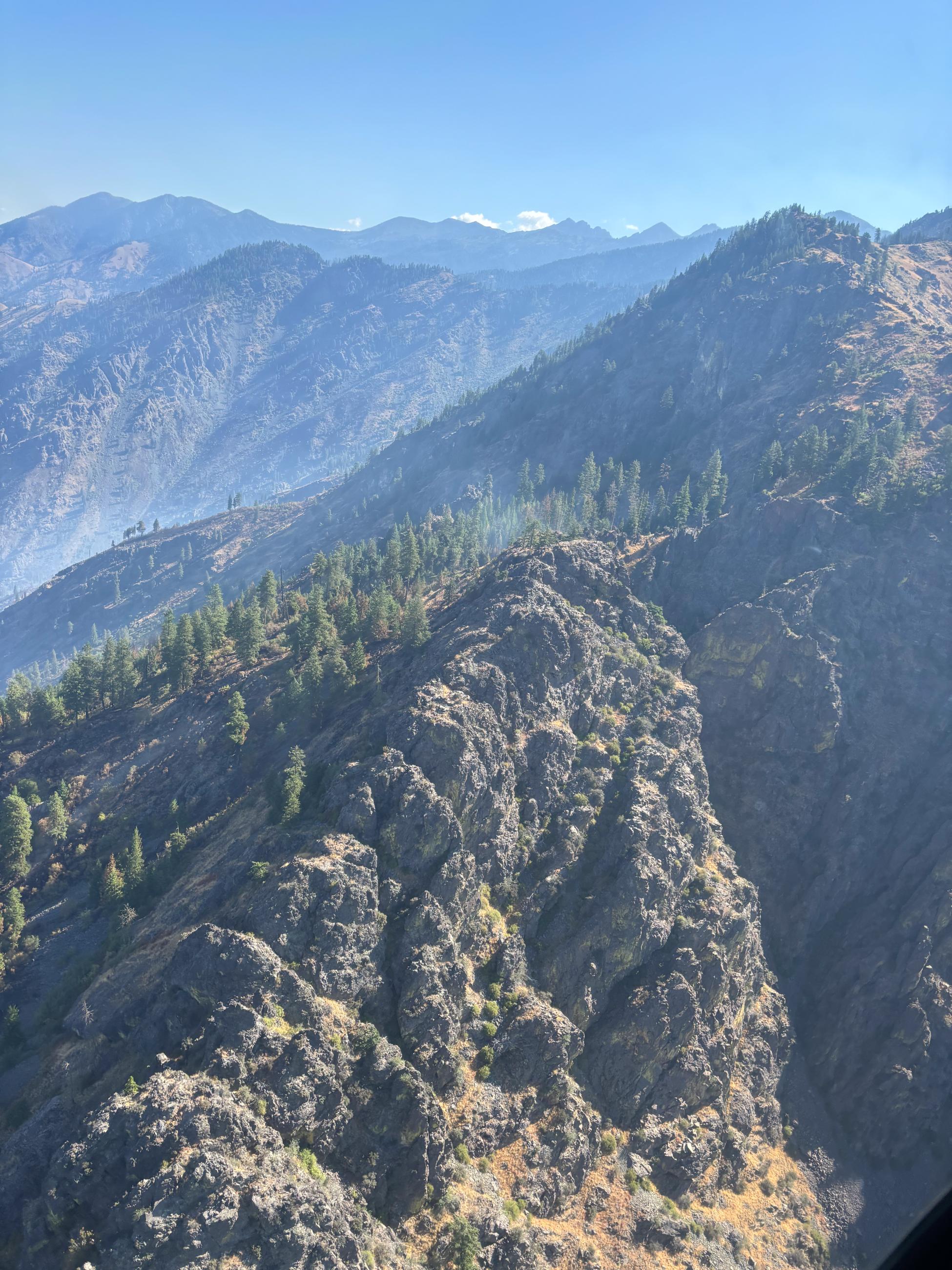
The Cliff Mountain Fire started by lightning on July 25th in Hells Canyon National Recreation Area in wilderness just below Hells Canyon Dam 25 miles east of Joseph, Oregon in Adams and Idaho Counties, Idaho. It was once two fires, the Muddy Fire and the Cliff Mountain Fire, which burned into each other. Fire growth is limited due to steep rocks.
| Current as of | Fri, 08/16/2024 - 10:54 |
|---|---|
| Incident Type | Wildfire |
| Cause | Lightning/Natural |
| Date of Origin | |
| Location | 25 Miles East of Joseph, Oregon |
| Incident Commander | Wallowa Whitman National Forest |
| Coordinates |
45 ° 15' 30'' Latitude
-116° 40' 53
'' Longitude
|
| Total Personnel: | 0 |
|---|---|
| Size | 1,108 Acres |
| Percent of Perimeter Contained | 75% |
| Estimated Containment Date | 8/25/2024 |
| Fuels Involved | South, west, and east slopes are characterized by moderate to heavy fuel loads of tall grasses with continuous areas of brush and timber. Drainage bottoms and north-facing slopes have dense mixed conifer stands. Ridges and rocky outcroppings restrict fire spread in higher elevations. |
| Significant Events | Minimal fire behavior and no growth is expected. |
| Planned Actions |
Aircraft available to the incident will be utilized to evaluate any potential fire activity. Should any growth occur action will be taken to minimize impacts to identified values at risk. |
|---|---|
| Projected Incident Activity |
12 hours: The fire is expected to remain within the current perimeter with smoldering fire behavior. 24 hours: The fire is expected to remain within the current perimeter with smoldering fire behavior. 48 hours: The fire is expected to remain within the current perimeter with smoldering fire behavior. 72 hours: The fire is expected to remain within the current perimeter with smoldering fire behavior. Anticipated after 72 hours: The fire is expected to remain within the current perimeter with smoldering fire behavior. |
| Weather Concerns | A few showers and thunderstorms happened this morning as a low pressure system passed through the area. A few sprinkles to a few hundredths of an inch of rain fell. Clouds began to break apart by early afternoon and temperatures rose into the upper 60s to near 80. Relative humidity dropped to 27-36%. Downslope NE flow in the morning changed to W-SW in the afternoon with gusts reaching 20 mph. Another round of showers and thunderstorms is possible this evening while winds become NW. Friday's weather looks similar to Wednesday: cool and dry with some cumulus clouds in the afternoon. |
|---|