
Highlighted Media

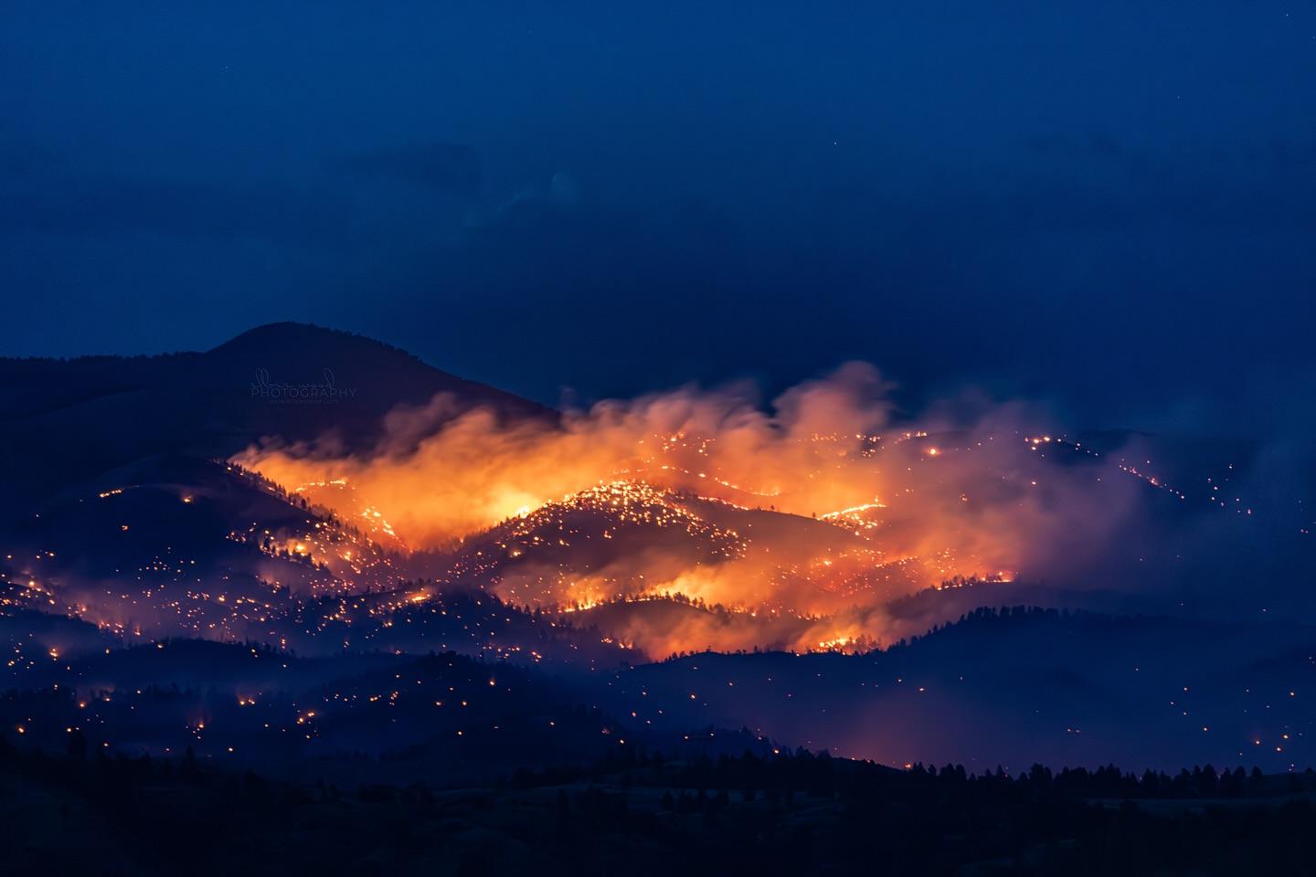
The Horse Gulch Fire was first reported the afternoon of July 9, 2024. It grew rapidly on both July 10 and 11. The fire is located about 5 miles south of York, and 2 miles north of Canyon Ferry. Fire behavior has been very active and is in dense timber with heavy dead and down fuels.
Beginning at 12:01 am on Saturday, July 27th:
The Helena-Lewis and Clark National Forest and the BLM have made the following changes to closures related to the Horse Gulch Fire:
Helena-Lewis and Clark National Forest Closure changes:
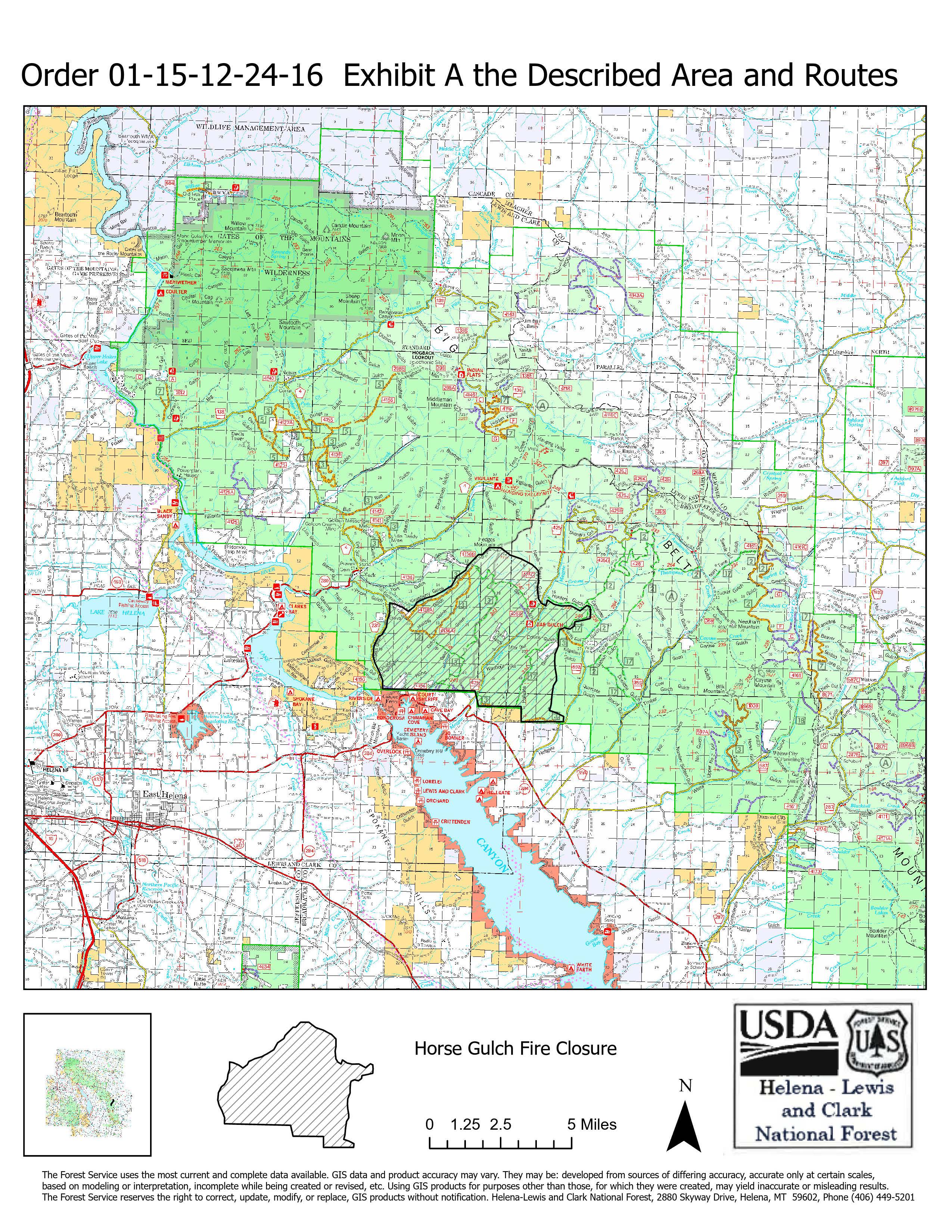
Road and Area Closure Changes: This closure applies to the following NFS lands, roads, and trails approximately 17 miles northeast of Helena, MT. In general, the closure is the fire perimeter bounded on the west side by County Road 231 (road NOT closed), turning north at the intersection of County Road 231 and Forest Service system road 4136-A3 to include 4136-A3 to its intersection with Forest Service system road 4136-B1 to include the 4136-B1 road to Hedges Mountain, then going southeast along the ridgeline to include Forest Service system road 425-C2 and 425-C1 to the intersection of the Magpie Road/Forest Service system road 245 then continuing east below trail 239 (trail NOT closed) to the intersection with trail 240, going south and including trail 240 to the intersection of the top of road 693-B1 (road NOT closed), then due south down the ridge to the Hellgate trailhead/Forest boundary then bounded on the south by the National Forest System lands boundary.
Trail Closures: All miles of Forest Service System trails:
- Townsend Ranger District: 240, 241, 242, 243
- Helena Ranger District: 241, 243, 245
Road Closures: Forest Service System roads:
- Townsend Ranger District: 425, 425A1, 425C1, 425C2, 425M1, 242
- Helena Ranger District: 4136A2, 4136A3, 4136A4, 4136B1
Area Closure: All of the National Forest System lands within the Horse Gulch fire perimeter: T11N, R01W sections 12-14, 21-28, 33-36; T11N, R01E sections 7-8, 17-22, 28-33; T10N, R01E sections 4-6.
Other - the following recreation sites are within the described area and therefore not available to the public:
Bar Gulch Cabin, Never Sweat trailhead, Cave Gulch trailhead
Due to the closure of road 425 within the fire perimeter, the Hunters Gulch trailhead is only accessible from the north, not from Highway 284.
The BLM has rescinded all closures related to the Horse Gulch Fire:
ORDER NUMBER LLMTB070-24-04-HD: Small-scale closure, pursuant to Title 43, Code of Federal Regulations, Section 9212, previously invoked by Order LLMTB070-24-01-HD is hereby rescinded for all lands administered by the Bureau of Land Management, Butte Field Office.
BLM lands east of Hauser Lake:
T10N, R1W, Sections 5, 6
T11N, R1W, Sections 30, 31, 32
T11N, R2W, Sections 12, 13, 23, 24, 25, 26, 36
BLM lands east of Canyon Ferry Reservoir:
T10N, R1E, Sections 5, 6, 14
The Horse Gulch Fire was first reported the afternoon of July 9, 2024. It grew rapidly on both July 10 and 11. The fire is located about 5 miles south of York, and 2 miles north of Canyon Ferry. Fire behavior has been very active and is in dense timber with heavy dead and down fuels.
Beginning at 12:01 am on Saturday, July 27th:
The Helena-Lewis and Clark National Forest and the BLM have made the following changes to closures related to the Horse Gulch Fire:
Helena-Lewis and Clark National Forest Closure changes:
Road and Area Closure Changes: This closure applies to the following NFS lands, roads, and trails approximately 17 miles northeast of Helena, MT. In general, the closure is the fire perimeter bounded on the west side by County Road 231 (road NOT closed), turning north at the intersection of County Road 231 and Forest Service system road 4136-A3 to include 4136-A3 to its intersection with Forest Service system road 4136-B1 to include the 4136-B1 road to Hedges Mountain, then going southeast along the ridgeline to include Forest Service system road 425-C2 and 425-C1 to the intersection of the Magpie Road/Forest Service system road 245 then continuing east below trail 239 (trail NOT closed) to the intersection with trail 240, going south and including trail 240 to the intersection of the top of road 693-B1 (road NOT closed), then due south down the ridge to the Hellgate trailhead/Forest boundary then bounded on the south by the National Forest System lands boundary.
Trail Closures: All miles of Forest Service System trails:
- Townsend Ranger District: 240, 241, 242, 243
- Helena Ranger District: 241, 243, 245
Road Closures: Forest Service System roads:
- Townsend Ranger District: 425, 425A1, 425C1, 425C2, 425M1, 242
- Helena Ranger District: 4136A2, 4136A3, 4136A4, 4136B1
Area Closure: All of the National Forest System lands within the Horse Gulch fire perimeter: T11N, R01W sections 12-14, 21-28, 33-36; T11N, R01E sections 7-8, 17-22, 28-33; T10N, R01E sections 4-6.
Other - the following recreation sites are within the described area and therefore not available to the public:
Bar Gulch Cabin, Never Sweat trailhead, Cave Gulch trailhead
Due to the closure of road 425 within the fire perimeter, the Hunters Gulch trailhead is only accessible from the north, not from Highway 284.
The BLM has rescinded all closures related to the Horse Gulch Fire:
ORDER NUMBER LLMTB070-24-04-HD: Small-scale closure, pursuant to Title 43, Code of Federal Regulations, Section 9212, previously invoked by Order LLMTB070-24-01-HD is hereby rescinded for all lands administered by the Bureau of Land Management, Butte Field Office.
BLM lands east of Hauser Lake:
T10N, R1W, Sections 5, 6
T11N, R1W, Sections 30, 31, 32
T11N, R2W, Sections 12, 13, 23, 24, 25, 26, 36
BLM lands east of Canyon Ferry Reservoir:
T10N, R1E, Sections 5, 6, 14
| Current as of | Fri, 11/15/2024 - 11:28 |
|---|---|
| Incident Time Zone | America/Denver |
| Incident Type | Wildfire |
| Cause | Human-caused |
| Date of Origin | |
| Location | 1/2 mile north of Canyon Ferry Dam near Helena, Montana |
| Incident Commander | A Type 3 organization with Incident Commander Anthony Emacio assumed command of the Horse Gulch Fire on July 23, 2024 at 6:00am. |
| Coordinates |
46° 41' 16.8'' Latitude
-111° 41' 47.8
'' Longitude
|
| Total Personnel: | 95 |
|---|---|
| Size | 15,167 Acres |
| Percent of Perimeter Contained | 100% |
| Estimated Containment Date | 08/14/2024 |
| Fuels Involved | Timber (Grass and Understory) Brush (2 feet) Timber (Litter and Understory) Cured grass has facilitated most fire spread on this incident. There is also a significant dead and down component across the landscape. ERCs are greater than 97th percentile. |
| Significant Events | Minimal Smoldering Fire behavior is limited to isolated smoldering of stumps and heavy fuels. |
| Planned Actions |
Transfer of command from Emacio {ICJ) to Wittenberg {IC4) will occur at 0600 tomorrow. The type 4 organization will continue to patrol. No further suppression or repair work is required at this time. |
|---|---|
| Projected Incident Activity |
Fire weather watch will be in effect. Persistent hot, dry conditions continue. Thunderstorms are possible. 12 hours: Most heavy fuels should be fully combusted. Some stumps and heavy fuels may continue to smolder. Smoke should be minimal. 24 hours: Most heavy fuels should be fully combusted. Smoke should be minimal 48 hours: Most heavy fuels should be fully combusted. Smoke should be minimal 72 hours: Most heavy fuels should be fully combusted. Smoke should be minimal |
| Weather Concerns | Today was cooler than previous OPs, with max temperatures in the mid-S0s. RHs remain low, with minimums around 10-15%. No thunderstorms are expected to track near the fire area today, however storms may return tomorrow. |
|---|