
This Inciweb page is intended to provide a summary of wildfire incidents taking place in the Payette National Forest's part of the Frank Church River of No Return Wilderness. Specific fires that are of large size or are threatening value at risk will have individual Inciweb pages in addition to this summary page - links to those individual Inciweb pages are provided below.
There is a misconception that all wildfires within a wilderness area are what some people term as "let burn" fires. The Forest Service does not have a policy termed as "let burn," and in fact all wildfires whether within a wilderness or outside a wilderness are evaluated by looking at the values at risk, burning indices, and firefighter and public safety to determine the specific strategies that will be taken on every wildfire.
A Forest may utilize all the wildfire tools available when taking actions for an unplanned ignition whether lightning caused, or human caused – there is no one right answer nor requirement for every wildfire to be addressed in a given way as every fire is different and needs to be addressed based on the characteristic of that fire and the values at risk. We use all available tools and technologies to ensure proactive fire detection, risk assessments, fire response, and post-fire recovery. Every wildfire receives a risk-informed response with effective strategies at the local level.
Standard wildfire strategies are Suppression, Containment/Confinement, Zone-Point Protection and Monitor. Any combination of these strategies can be and typically are use on every wildfire incident whether within or outside a wilderness area.
Our goal for managing wildfire in the Frank Church River of No Return Wilderness is:
- Lightning caused fires will be permitted to play, as nearly as possible, their natural ecological role within the Wilderness, if risks and consequences of the wildfire can be reduced to an acceptable level.
The Frank Church River of No Return Wilderness Incident Management Operating Plan outlines processes and procedures for addressing wildfire is the Wilderness.
The Forest Service Manual and the Frank Church River of No Return Wilderness Management Plan directs us to “Conduct all fire management activities within wilderness in a manner compatible with overall wilderness management objectives.” We strive to use tactics and equipment that causes the least disturbance to wilderness landscapes and visitor solitude and locate fire camps, heli-spots, and other temporary facilities or improvements outside of the wilderness, whenever feasible. We rehabilitate disturbed areas within wilderness to as natural an appearance as possible.
Active Wildfires within the Payette’s part of the Frank Church River of No Return Wilderness Area.
McCall Ranger District
The Fang and Frangelica Fires have been declared as OUT.
Krassel Ranger District
Monumental Fire – 7 acres, detected evening of August 6. Located approximately 6 miles to the NE of the Stibnite Mining District and under a full suppression strategy. Controlled and declared out.
These two fires remain active with the Wilderness.
Parks Fire – The fire is at 5,978 acres and located on the west side of lower Chamberlain Creek down to the Salmon River, and up to Mule Creek Point ridge, then southwest into Mule Creek and into Queens Creek. The cold front that brought strong gusty winds to the area on October 4th fanned the flames on the Parks Fire on the southwest flank into Queens Creek and up to the ridge above McCalla Creek. There is scattered heat on the north flank along the Mule Creek ridge. There is currently low to moderate fire activity taking place on the southwest flank of the fire.
Monitoring of this fire has shown that favorable effects are taking place across the burn area. The Chamberlain bridge structure protection measures have been removed and several firefighters hiked into Artic Point Lookout to unwrap the structure and all is well at the site. No damage was done to the bridge or the lookout facility. This fire is within the Frank Church River of No Return Wilderness. This fire is using a Zone/Point protection strategy while allowing this lightning caused to play, as nearly as possible, its natural ecological role within the Wilderness.
- No area or trail closures are in place for this fire - people recreating in this area need to be alert for fire related hazards.
- For any concerns regarding to rafting along the Salmon River, call the Salmon-Challis National Forest River Desk at 208-481-2625.
- Idpaf Parks Fire Information | InciWeb (wildfire.gov)
Farrow Fire – The fire is at 3,084 acres. The fire was detected on August 5th and caused by lightning. Initially located approximately 5.5 miles east-southeast of Cold Meadows Guard Station. The cold front that passed over the fire area on October 4th fanned the flames of the Farrow fire with fire spread to the southwest down towards the South Fork of Cottonwood Creek sand into the upper drainage of Iodine Creek. Scattered heat remains throughout the rest of the fire area. This the fire 2.5 miles from Cold Meadows Guard Station a fire crew is being sent in with structure protection equipment to address values at risk at Cold Meadows.
Monitoring of this fire has shown that favorable effects are taking place across the burn area. This lightning caused fire is being permitted to play, as nearly as possible, its natural ecological role within the Wilderness. Zone/Point Protection measures will be taken if necessary and is being monitored by air.
- No area or trail closures are in place for this fire - people recreating in this area need to be alert for fire related hazards.
- Idpaf Farrow Fire Information | InciWeb (wildfire.gov)
These fires have shown no activity over the last two week but have not been declared out.
Cotton Fire - 104 acres – detected on September 9. Located approximately 5 miles south, southeast from Cold Meadows Guard Station. This fire is within the Frank Church River of No Return Wilderness and a Monitor and Zone/Point Protection strategy is being used on this fire.
Copper Fire – 2,129 acres and was detected on September 2. Located approximately 10 miles east of Edwardsburg and 1 mile west of Routon Peak in the Monumental Creek drainage. The fire has crossed Monumental Creek and is approximately 1.5 miles from Monumental Ranch, but this is not furthering the risk to the ranch. Ranch operations are continuing to take place by the owner. Structure protection equipment has been left in place as a protective measure regarding the Logan Fire. This fire is within the Frank Church River of No Return Wilderness and a Monitor and Zone/Point Protection strategy is being used on this fire.
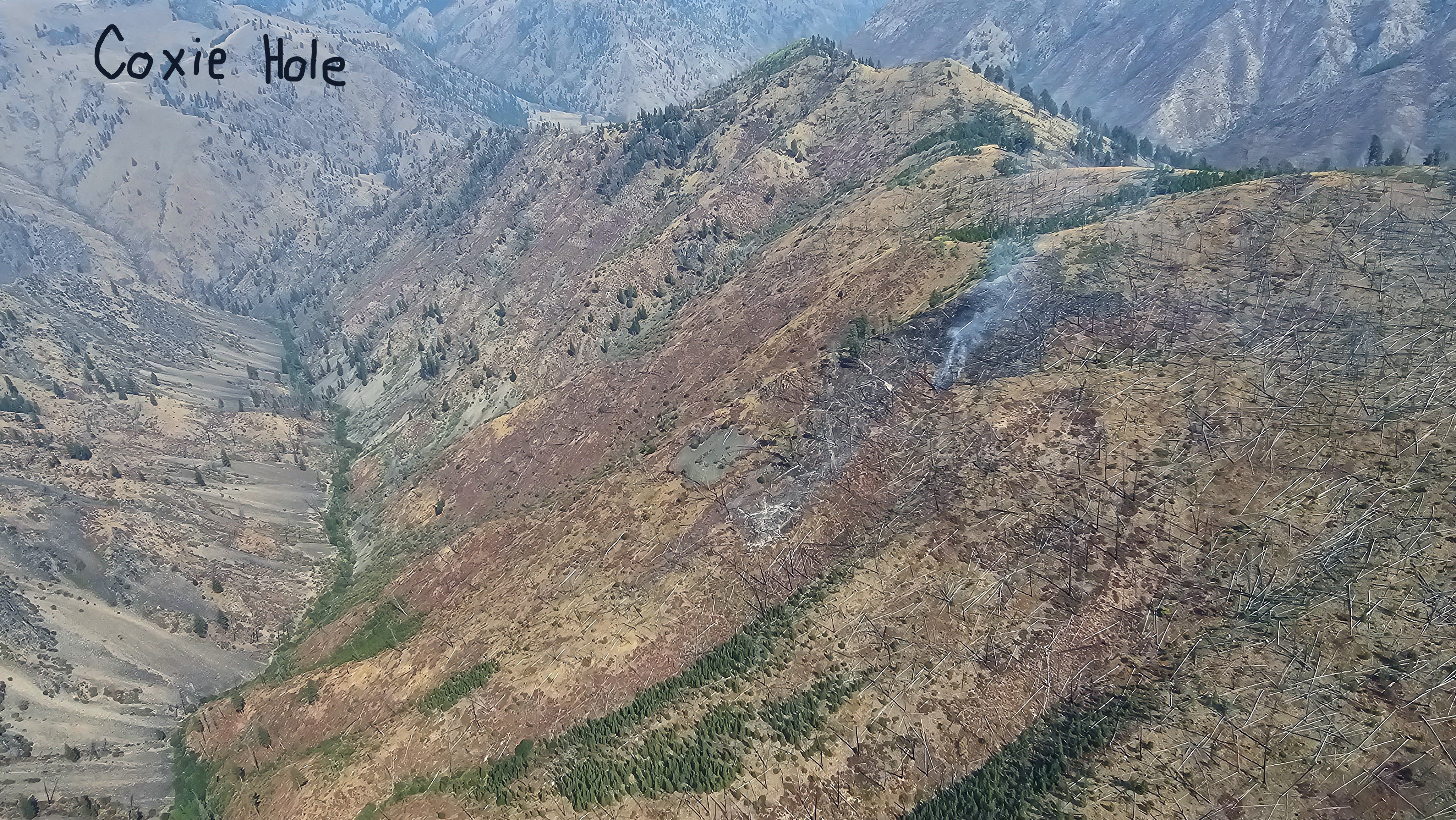
Coxie Hole Fire – 194 acres. Detected September 2. Located approximately 14 miles east of Edwardsburg and just south of Big Creek. Most of the fire looks to be burned out. This fire is within the Frank Church River of No Return Wilderness and a Monitor and Zone/Point Protection strategy is being used on this fire.
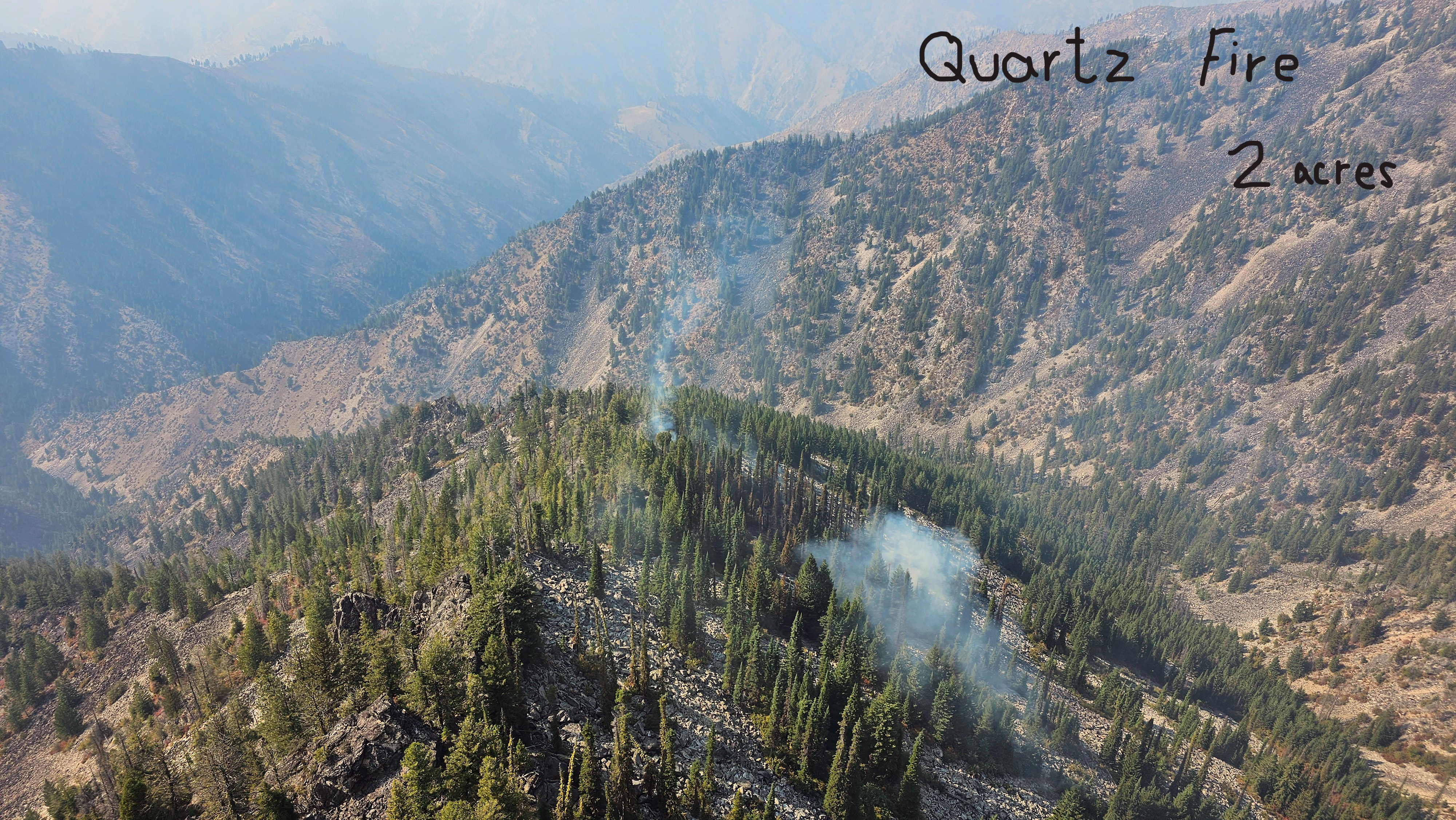
Quartz Fire – 2 acres. Located on the Krassel Ranger District in upper Fivemile Creek approximately 2.5 miles west, southwest of Sheepeater Lookout. This fire is within the Frank Church River of No Return Wilderness and a Monitor and Zone/Point Protection strategy is being used on this fire. Nearest value at risk is three air miles away at Fivemile Bar along the Salmon River.
Burnt Creek – The fire is at 2,665 acres as of September 9. It was detected on August 13 and is located in Burnt Creek within the Big Creek drainage. The fire burned to the Middle Fork of the Salmon River. No fire activity has been taking place for over a month. Personal flew into Taylor Ranch to remove and backhaul structure protection equipment, then hike the trail from the Middle Fork up Big Creek to remove fire warning signs. This fire is within the Frank Church River of No Return Wilderness. A Zone/Point Protection Strategy is being used on this fire and a structure protection plan for values at risk in the area has been implemented.
This Inciweb page is intended to provide a summary of wildfire incidents taking place in the Payette National Forest's part of the Frank Church River of No Return Wilderness. Specific fires that are of large size or are threatening value at risk will have individual Inciweb pages in addition to this summary page - links to those individual Inciweb pages are provided below.
There is a misconception that all wildfires within a wilderness area are what some people term as "let burn" fires. The Forest Service does not have a policy termed as "let burn," and in fact all wildfires whether within a wilderness or outside a wilderness are evaluated by looking at the values at risk, burning indices, and firefighter and public safety to determine the specific strategies that will be taken on every wildfire.
A Forest may utilize all the wildfire tools available when taking actions for an unplanned ignition whether lightning caused, or human caused – there is no one right answer nor requirement for every wildfire to be addressed in a given way as every fire is different and needs to be addressed based on the characteristic of that fire and the values at risk. We use all available tools and technologies to ensure proactive fire detection, risk assessments, fire response, and post-fire recovery. Every wildfire receives a risk-informed response with effective strategies at the local level.
Standard wildfire strategies are Suppression, Containment/Confinement, Zone-Point Protection and Monitor. Any combination of these strategies can be and typically are use on every wildfire incident whether within or outside a wilderness area.
Our goal for managing wildfire in the Frank Church River of No Return Wilderness is:
- Lightning caused fires will be permitted to play, as nearly as possible, their natural ecological role within the Wilderness, if risks and consequences of the wildfire can be reduced to an acceptable level.
The Frank Church River of No Return Wilderness Incident Management Operating Plan outlines processes and procedures for addressing wildfire is the Wilderness.
The Forest Service Manual and the Frank Church River of No Return Wilderness Management Plan directs us to “Conduct all fire management activities within wilderness in a manner compatible with overall wilderness management objectives.” We strive to use tactics and equipment that causes the least disturbance to wilderness landscapes and visitor solitude and locate fire camps, heli-spots, and other temporary facilities or improvements outside of the wilderness, whenever feasible. We rehabilitate disturbed areas within wilderness to as natural an appearance as possible.
Active Wildfires within the Payette’s part of the Frank Church River of No Return Wilderness Area.
McCall Ranger District
The Fang and Frangelica Fires have been declared as OUT.
Krassel Ranger District
Monumental Fire – 7 acres, detected evening of August 6. Located approximately 6 miles to the NE of the Stibnite Mining District and under a full suppression strategy. Controlled and declared out.
These two fires remain active with the Wilderness.
Parks Fire – The fire is at 5,978 acres and located on the west side of lower Chamberlain Creek down to the Salmon River, and up to Mule Creek Point ridge, then southwest into Mule Creek and into Queens Creek. The cold front that brought strong gusty winds to the area on October 4th fanned the flames on the Parks Fire on the southwest flank into Queens Creek and up to the ridge above McCalla Creek. There is scattered heat on the north flank along the Mule Creek ridge. There is currently low to moderate fire activity taking place on the southwest flank of the fire.
Monitoring of this fire has shown that favorable effects are taking place across the burn area. The Chamberlain bridge structure protection measures have been removed and several firefighters hiked into Artic Point Lookout to unwrap the structure and all is well at the site. No damage was done to the bridge or the lookout facility. This fire is within the Frank Church River of No Return Wilderness. This fire is using a Zone/Point protection strategy while allowing this lightning caused to play, as nearly as possible, its natural ecological role within the Wilderness.
- No area or trail closures are in place for this fire - people recreating in this area need to be alert for fire related hazards.
- For any concerns regarding to rafting along the Salmon River, call the Salmon-Challis National Forest River Desk at 208-481-2625.
- Idpaf Parks Fire Information | InciWeb (wildfire.gov)
Farrow Fire – The fire is at 3,084 acres. The fire was detected on August 5th and caused by lightning. Initially located approximately 5.5 miles east-southeast of Cold Meadows Guard Station. The cold front that passed over the fire area on October 4th fanned the flames of the Farrow fire with fire spread to the southwest down towards the South Fork of Cottonwood Creek sand into the upper drainage of Iodine Creek. Scattered heat remains throughout the rest of the fire area. This the fire 2.5 miles from Cold Meadows Guard Station a fire crew is being sent in with structure protection equipment to address values at risk at Cold Meadows.
Monitoring of this fire has shown that favorable effects are taking place across the burn area. This lightning caused fire is being permitted to play, as nearly as possible, its natural ecological role within the Wilderness. Zone/Point Protection measures will be taken if necessary and is being monitored by air.
- No area or trail closures are in place for this fire - people recreating in this area need to be alert for fire related hazards.
- Idpaf Farrow Fire Information | InciWeb (wildfire.gov)
These fires have shown no activity over the last two week but have not been declared out.
Cotton Fire - 104 acres – detected on September 9. Located approximately 5 miles south, southeast from Cold Meadows Guard Station. This fire is within the Frank Church River of No Return Wilderness and a Monitor and Zone/Point Protection strategy is being used on this fire.
Copper Fire – 2,129 acres and was detected on September 2. Located approximately 10 miles east of Edwardsburg and 1 mile west of Routon Peak in the Monumental Creek drainage. The fire has crossed Monumental Creek and is approximately 1.5 miles from Monumental Ranch, but this is not furthering the risk to the ranch. Ranch operations are continuing to take place by the owner. Structure protection equipment has been left in place as a protective measure regarding the Logan Fire. This fire is within the Frank Church River of No Return Wilderness and a Monitor and Zone/Point Protection strategy is being used on this fire.
Coxie Hole Fire – 194 acres. Detected September 2. Located approximately 14 miles east of Edwardsburg and just south of Big Creek. Most of the fire looks to be burned out. This fire is within the Frank Church River of No Return Wilderness and a Monitor and Zone/Point Protection strategy is being used on this fire.
Quartz Fire – 2 acres. Located on the Krassel Ranger District in upper Fivemile Creek approximately 2.5 miles west, southwest of Sheepeater Lookout. This fire is within the Frank Church River of No Return Wilderness and a Monitor and Zone/Point Protection strategy is being used on this fire. Nearest value at risk is three air miles away at Fivemile Bar along the Salmon River.
Burnt Creek – The fire is at 2,665 acres as of September 9. It was detected on August 13 and is located in Burnt Creek within the Big Creek drainage. The fire burned to the Middle Fork of the Salmon River. No fire activity has been taking place for over a month. Personal flew into Taylor Ranch to remove and backhaul structure protection equipment, then hike the trail from the Middle Fork up Big Creek to remove fire warning signs. This fire is within the Frank Church River of No Return Wilderness. A Zone/Point Protection Strategy is being used on this fire and a structure protection plan for values at risk in the area has been implemented.
| Current as of | Tue, 10/22/2024 - 17:20 |
|---|---|
| Incident Type | Wildfire |
| Coordinates |
45° 9' 51'' Latitude
-115° 9' 54
'' Longitude
|