
Highlighted Activity
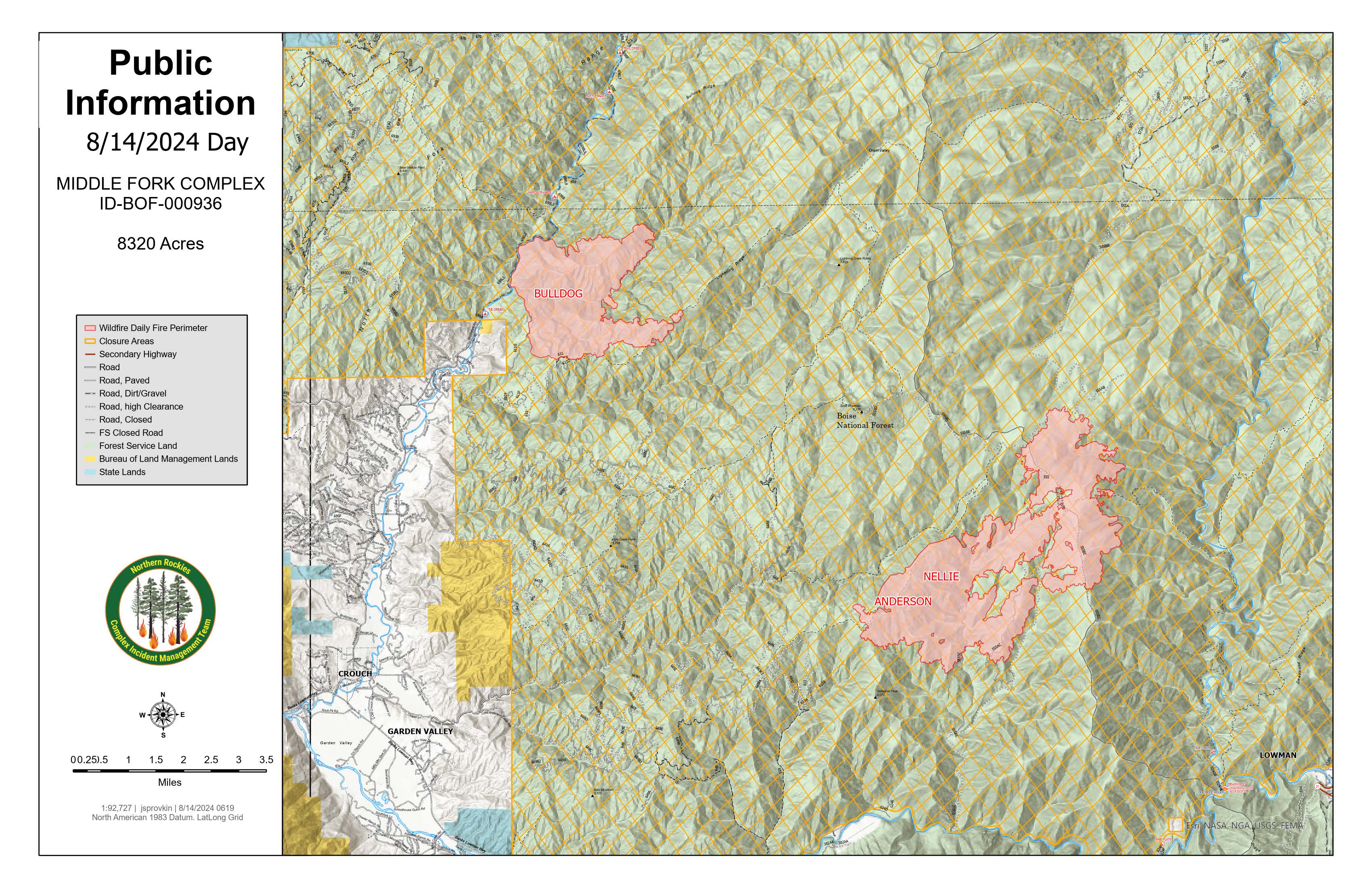
On August 5th, 2024, a storm with lightning moved through the area with a series of ground strikes which ignited the Middle Fork Complex (consisting of the Bulldog Fire, Nellie Fire, and Anderson Fire). The Anderson Fire was the first fire reported on August 5, 2024 at 4:16 PM, followed by the Bulldog Fire at 5:03 PM, and the Nellie Fire on August 6, 2024 at 8:29 PM.
On August 12th the Nellie and Anderson fires merged and will now be treated as one fire and retain the name Nellie.
The fires are burning in steep, rugged terrain making access difficult in some areas. Ensuring firefighter safety and protecting life and property are of the utmost importance.
The Northern Rockies Complex Incident Management Team 5, assumed command of the Middle Fork Complex (Bulldog, Nellie, and Anderson fires), and the Bulltrout and Wapiti fires at 6AM on August 10, 2024 with Incident Commander Rick Connell. The team is working in cooperation with local fire managers, interagency partners and community officials to utilize resources to protect prioritized values.
| Current as of | Wed, 08/14/2024 - 10:50 |
|---|---|
| Incident Time Zone | America/Denver |
| Incident Type | Wildfire |
| Cause | Lightning |
| Date of Origin | |
| Location | 9 miles east of Garden Valley, ID |
| Incident Commander | Rick Connell, Northern Rockies Complex Incident Management Team 5 |
| Coordinates |
44° 10' 18'' Latitude
-115° 47' 50
'' Longitude
|
| Total Personnel: | 388 |
|---|---|
| Size | 7,701 Acres |
| Percent of Perimeter Contained | 0% |
| Estimated Containment Date | 10/01/2024 |
| Fuels Involved | Predominant fuels are timber understory, timber liter, and dry climate shrubs with inter-mixed conifer stands and heavy dead fuels.
|
| Significant Events | Active fire activity was observed, with surface burning in timber/ understory, group torching, short-range spotting into receptive dead fuels. Fire behavior dependent on sky clearing. Live fuels beginning to show signs of availability. Fire spread heavily influenced by availability of dead surface fuels and terrain. Most active fire behavior observed along ridge lines most exposed to general winds..
|
| Planned Actions |
Bulldog Fire: Firefighters Improve MiddleFork Road, look for opportunities to check fire spread to the west and north. Continue direct and indirect line construction from the Middle Fork Payette River to 611G road and then on towards Road 611. Crews will use direct and indirect tactics to prevent the fire from moving south. Strategic firing operations will be implemented when conditions are conducive. Nellie Fire: Firefighters will continue point protection of the fire lookouts and communication tower.
|
|---|---|
| Projected Incident Activity |
Bulldog: There is a high potential that the fire will continue to spread actively to the east and north. Group torching, short-range spotting, and terrain driven runs through dead and fine fuels.
Nellie: Continued growth in various directions due to terrain influences and exposed ridge lines. Group torching, short-range spotting, and uphill runs continue to be the pattern of fire spread. |
| Remarks |
Bulldog Fire is 2,585 acres and has 0% containment. On August 12th the Nellie and Anderson fires merged and will now be treated as one fire and retain the name Nellie. The current containment on the newly combined Nellie fire is 0%. Nellie Fire is currently 5116 acres and 0% containment. The Boise County Sheriff's Office continues to maintain the Level 2 evacuation notice for residents A closure is implemented over a large portion of the forest to provide greater public and firefighter safety. The closure contains roads and trails near the Bulldog and Nellie fires. For all forest closures, visit the Forest Alerts & Notices webpage. The fire information phone number for the Middle Fork Fire Complex is (208) 992-3045 Email contact 2024.middleforkcomplex@firenet.gov |
| Weather Concerns | A passing weather system brought showers to the area Tuesday morning, along with cooler temperatures and higher relative humidity. Rainfall amounts across the fire area were less than 0.10 inches. This system moved away from the area by early afternoon, however the increase in moisture kept daytime RH values elevated above 25% across the fire area, while temperatures remained in the upper 60s and 70s. Winds continued to be terrain driven, with west winds gusting to near 15 mph along upper ridgelines during the afternoon.
|
|---|