
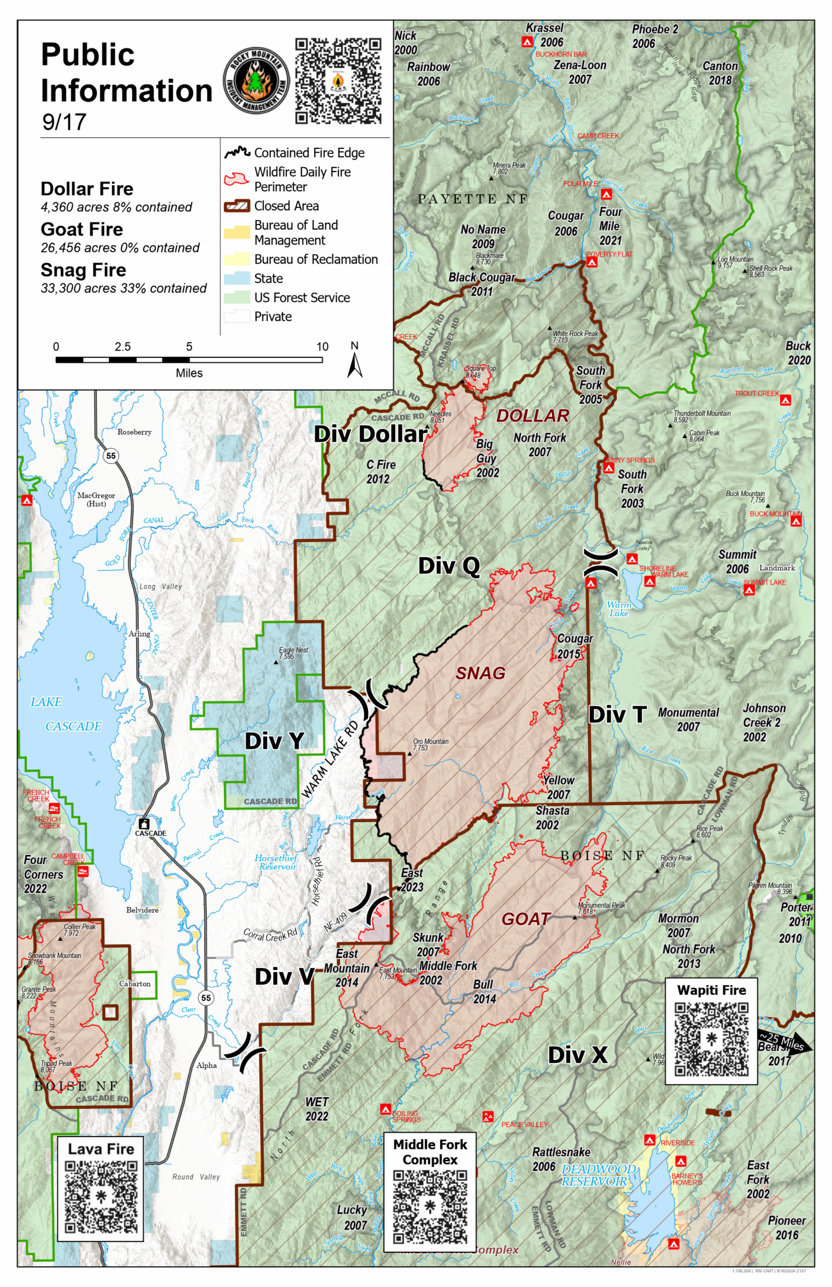

The Dollar Fire, Snag Fire, and the Goat Fire are part of the West Mountain Fires currently managed by the Rocky Mountain Complex Incident Management Team Three under Incident Commander Bill Waln. This page is specific to the Dollar Fire.
For information on evacuations and road closures so be sure to follow the Valley County Sheriff's Facebook page or call them at (208) 382-5160.
To learn more about the Ready, Set, GO evacuation system click this link.
The Boise National Forest, Idaho Department of Lands, and Bureau of Land Management are in Stage 1 fire restrictions on state, endowment, private and federal lands within the West Central Mountains Fire Restrictions Zone. For more information, visit the Idaho fires Restrictions website at: https://www.idl.idaho.gov/fire-management/fire-restrictions-finder/
| Current as of | Wed, 09/25/2024 - 18:15 |
|---|---|
| Incident Time Zone | America/Boise |
| Incident Type | Wildfire |
| Cause | Lightning/Natural |
| Date of Origin | |
| Location | 18 miles NE of Cascade, Idaho |
| Incident Commander | Bill Waln IC Rocky Mountain CIMT3 Dylan Rader IC(T) |
| Coordinates |
44° 43' 2'' Latitude
-115° 48' 39
'' Longitude
|
| Total Personnel: | 1 |
|---|---|
| Size | 4,360 Acres |
| Percent of Perimeter Contained | 8% |
| Estimated Containment Date | 10/15/2024 |
| Fuels Involved | Timber (Grass and Understory) Closed Timber Litter Timber (Litter and Understory) Fuels primarily consist of Ponderosa Pine, Lodgepole pine, Douglas Fir and manzanita with moderate to heavy dead and down. Recent bug kill timber and fire scars have contributed to numerous snags. |
| Significant Events | Minimal Smoldering Cool, west conditions limited fire behavior to smoldering across the fire. |
| Planned Actions |
Monitoring fire movement in the areas near Square Top and Blackmare Lakes. |
|---|---|
| Projected Incident Activity |
12 hours: Cooler temperatures, higher humidity are forecast to occur which should limit fire activity and potential growth. 24 hours: Cool and wet weather returns and will further moisten fuels and inhibit growth. 48 hours: Cool and wet weather returns and will further moisten fuels and inhibit growth. 72 hours: Dryer and slightly warmer weather will allow fine fuels to begin to dry though no growth is expected. Anticipated after 72 hours: Dryer and slightly warmer weather will allow fine fuels to begin to dry though no growth is expected. |
| Remarks |
This incident is being prioritized with two other incidents (Snag, and Goat). Differences in resource numbers listed on the ICS-204s and reported in the ICS-209 are a result of sharing resources through lend/lease across all incidents being managed by Rocky Mountain CIMT3. |
| Weather Concerns | Light showers overnight gave way to a mostly sunny sky by early afternoon. Showers and thunderstomrs began to develop to the southwest of the fire area. Early afternoon temperatures ranged from the upper 50s to the mid 70s. Relative humidities ranged from the mid 40s to lower 60s. Winds were generally from the northwest at 5 to 10mph with gusts to 15 mph on the ridges and exposed areas. Forecast for Tuesday, 9/17/2024 A chilly and Damp day is expected with wetting rains once again. Temperatures will be 15 to 20 colder than Monday and will range from the lower 40s on the ridges to the lower 60s in the valleys. Winds will become southwest but remain light at less than 10mph. Relative humidity values are expected to remain in the 80s and 90s through much of the day. |
|---|