Single Publication
Could not determine your location.
Red Rock and Black Eagle Fire Update 09-23-2024
Red Rock Fire, Black Eagle Fire
Publication Type: News - 09/23/2024 - 08:31
FIRE ACTIVITY:
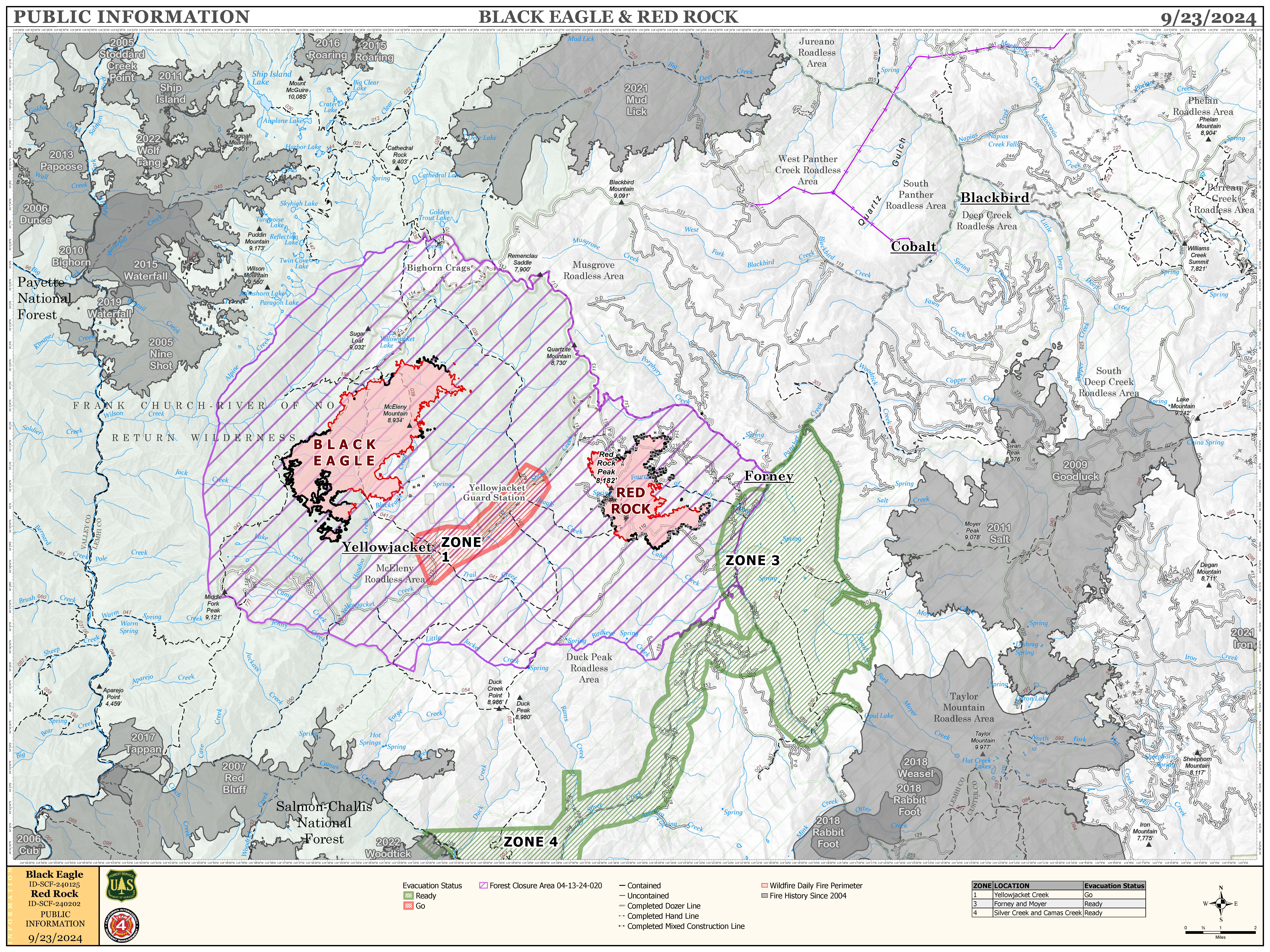
The Red Rock Fire is at 3,080 acres and 54% containment.
Yesterday, containment continued to grow significantly despite active fire behavior in the area surrounding Red Rock Peak. This area, characterized by heavy fuels, steep terrain, and conditions favorable for fire growth, has been the most active part of the fire. While crews successfully built a direct line north of Red Rock Peak, rising temperatures in the afternoon caused the fire to spread west of the 110 road, and resources were shifted to contain that growth.
Today's main goal is to keep the fire within its current boundaries, especially monitoring areas like the section south of Fourth of July Creek, where handline construction is still needed. Efforts to protect the 110 road and construct a handline north of Red Rock Peak will continue today. Fire crews also made notable strides in repairing and clearing roadways impacted by fire operations yesterday, and they will maintain these efforts today.
The Black Eagle fire is at 6,475 acres and 7% containment.
Yesterday, the northeastern edge of the Black Eagle Fire saw some increased activity, but most of it was in the wilderness area. Crews are working on hotspots along the southeast side of the fire near Black Eagle Creek and Black Eagle Mine. They’re establishing direct lines and removing hazardous trees along nearby roads.
Today, this work will continue, with more tree removal planned along the 60112 road. Crews will also focus on securing spot fires to the east and west of Black Eagle Creek and will work on mopping up spot fires on both sides of the creek.
WEATHER:
Today’s weather is predicted to be similar to yesterday’s, with temperatures hitting the low 60’s, slightly stronger winds out of the NW at around 10mph (with gusts up to 20mph), and increased cloud cover bringing higher humidity (between 32%-53%) to the area.
FIRE BEHAVIOR:
As the warming and drying trend continues, most of the forest’s fuels are becoming more available to burn. Therefore, fire behavior is likely to increase over the next few days. Although large portions of the fire are either in areas unlikely to support growth or are already encircled by handlines, this increased fire activity will make direct attack more challenging in areas like Red Rock Peak that do not have those advantages, particularly in the afternoons when temperatures hit their peak. Air support - such as helicopter bucket drops - will become an increasingly essential part of the fire containment effort.
FOREST CLOSURES:
For forest closure information please go to: https://www.fs.usda.gov/alerts/scnf/alerts-notices
EVACUATIONS:
For evacuation information in Lemhi County regarding these fires please go to: Emergency Management Department | Lemhi County, ID (lemhicountyidaho.org).

This is the PIO map for the Red Rock and Black Eagle fires for 09-23-24

 InciWeb