Single Publication
Red Rock and Black Eagle Fire Update 09-20-2024
Publication Type: News - 09/20/2024 - 12:29
FIRE ACTIVITY:
In the past 72 hours, a substantial arrival of federal and state resources from across the nation has arrived to assist in fighting the Red Rock and Black Eagle fires. This increase in resources will support our full suppression strategy and enable us to make significant progress toward getting containment on these fires.
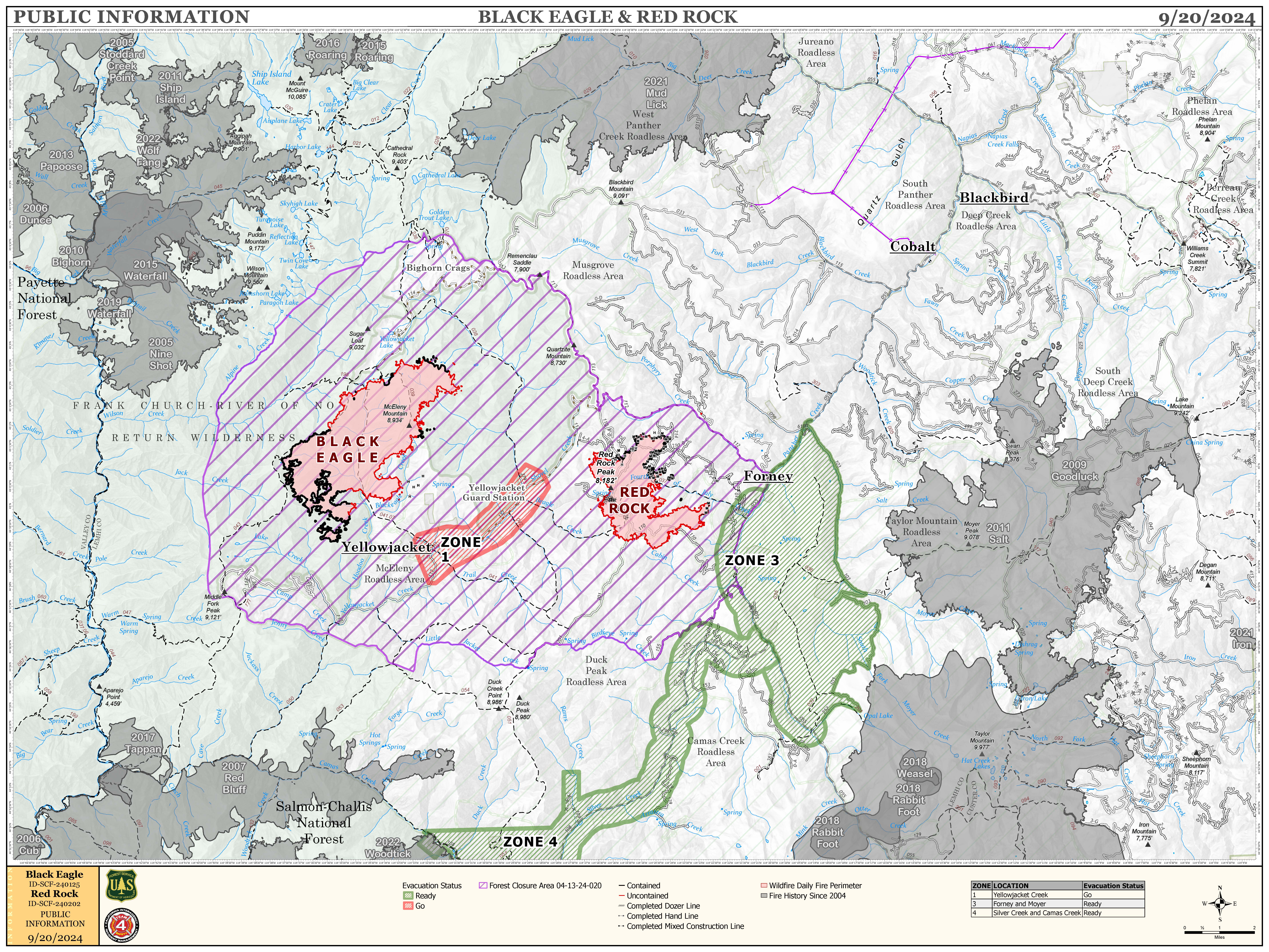
The Red Rock Fire is currently 3,055 acres and is 15% contained.
Units are actively repairing roads in the Red Rock fire area, including Panther Creek Road, with the aim of bettering access all the way to Road 10112. Crews are grading the roadways and chipping downed trees and branches along the edges. As containment efforts advance, these repairs will transition to long-term suppression rehabilitation.
Meanwhile, hotshot crews are spiked out in the south, scouting safe locations to go direct to increase containment efforts in the southern and western part of the fire. Additional crews are focusing on established containment lines, working to extend and connect them, particularly along the northern and eastern borders.
The Black Eagle Fire is currently 6,451 acres and is 4% contained.
Crews are actively using infrared cameras and helicopter flyovers to monitor the behavior of the Black Eagle Fire. The fire has shown very limited growth on both its western and eastern flanks, having burned into a rock scree with little to no vegetation. Similar observations have been noted on the northern side.
Meanwhile, a hotshot crew is spiked at the Yellow Jacket Guard Station, scouting locations for a direct attack on the fire near Black Eagle Mine in the southeast area. Additionally, a hand crew is also on site to assist with addressing hotspots.
In wildland firefighting, "spiked out" refers to a crew being stationed away from their base camp, typically in a remote location, to be closer to the fire line. This allows them to respond quickly to fire activity and conduct operations more efficiently. Crews often set up a temporary camp, or "spike camp," where they can rest and regroup while remaining ready for action.
WEATHER:
The weather today will likely be similar to yesterday, with cold weather and high humidity in the morning giving way to warmer temperatures and drier air around 11 AM. Winds will be blowing out of the west/southwest, averaging around 13 mph, with gusts up to 20 mph.
FIRE BEHAVIOR:
The warming and drying trend will likely cause fire activity to increase over the next few days, with the possibility of open flame and fire spread in addition to the increased burning of heavy dead and down fuels. Fire spread will most likely occur where steep slopes align with the wind or where there is a heavy fuel load, particularly west of Red Rock Peak. This increased activity will make direct attack more difficult than it has been the past few days.
FOREST CLOSURES:
Forest Closure Order 04-13-24-017 remains in place. Closure order 04-13-24-019 has been rescinded, and Forest Closure Order 04‐13‐24‐020 is now in place. The Salmon‐Challis National Forest has reduced the Black Eagle Fire Closure. The explanation of closure order #04-13-24-020 is as follows:
Described Roads
NFS lands, roads, and trails on the Salmon-Cobalt, and North Fork Ranger Districts of the Salmon-Challis National Forest within the area bounded by the following:
Beginning at the intersection of FS Road 112 and 055 (Panther Creek Rd) to the intersection of FS Road 112 and 113. Then following FS Road 113 to its intersection with trail 029 (FS Roads 112 and 113 are closed to the public). Then following the Frank Church River of No Return Wilderness Boundary to the Golden Trout Lake Trailhead, including the Big Horn Crags Campground and crossing over into the Frank Church River of No Return Wilderness and onto the ridge to the West of Wilson Creek, then going South to Middle Fork Peak. From Middle Fork Peak to the Frank Church River of No Return Wilderness Boundary to trail 053 then running along Little Jacket Creek to Trail 051, then following Trail 051 to Birdseye Creek to Forest Road 245 at its intersection with Panther Creek road 55. Then following the western side of FS Road 55 (Panther Creek), to the intersection of FS Road 55 and 112.
The purpose of this order is to protect public health and safety during the Black Eagle/Red Rock Fire. This Order shall be in effect from September 17, 2024, at 8:00 am until rescinded.
For more information please visit: https://www.fs.usda.gov/alerts/scnf/alerts-notices
EVACUATIONS:
Lemhi County has made changes in the evacuation zone statuses. The changes are as follows:
ZONE 1- WILL REMAIN IN “GO” STATUS
Yellowjacket drainage
ZONE 2- HAS BEEN RESCINDED
ZONE 3- WILL REMAIN IN “READY” STATUS
Zone 3: Forney to road #252 to road #103 and back to Moyer
ZONE 4- WILL REMAIN IN “READY” STATUS
Zone 4: Silver Creek, Rams Creek, and Camas Creek from Hammer Creek to White Goat Creek


Map of Black Eagle and Red Rock Fire - 9/20/24

 InciWeb