
Single Publication
Hayden Fire Closure Order #04-13-23-04, 7/21/23
Publication Type: Closures 07/29/2023
Order Number: # 04-13-23-04
U.S. Department of Agriculture, U.S. Forest Service
Salmon-Challis National Forest
Leadore Ranger District
Hayden Fire Closure Order
PROHIBITIONS
Pursuant to16 U.S.C. § 551 and 36 CFR 261.50(a) and (b), the following acts are prohibited on National Forest System (NFS) lands, roads and trails in the Leadore Ranger District, Salmon-Challis National Forest, shown on the attached map incorporated into this Order as Exhibit A (the “Described Area, Roads and Trails”):
- Going into or being upon the Described Area, 36 C.F.R. § 261.52 (e).
- Being on the Described Road, 36 C.F.R. § 261.54 (e).
- Being on the Described Trails, 36 C.F.R. § 261.55 (a).
EXEMPTIONS
Pursuant to 36 C.F.R. § 261.50(e), the following persons are exempt from this Order:
- Persons with Forest Service Permit No. FS-7700-48 (Permit for Use of Roads, Trails, or Areas Restricted by Regulation or Order), specifically exempting them from this Order or a written determination by a Forest Service authorized officer that a permit is not required under 36 C.F.R. § 251.50(e)(1) or (2).
- Any Federal, State, or local officer, or member of an organized rescue or fire fighting force in the performance of an official duty.
DESCRIBED AREA AND ROADS
All NFS lands, roads and trails on the Leadore Ranger District of the Salmon-Challis National Forest within the area bounded by the following: starting at the junction of the Salmon-Challis National Forest boundary and National Forest System Road (NFSR) #008 Hayden Creek Road, then following the Salmon-Challis National Forest Boundary to its intersection with Rye Grass Creek Road, then following the ridgeline south to the junction with NFSR #162 Kadletz Creek Road, then following NFSR #162 Kadletz Creek Road to the ridgeline southwest to the summit of Long Mountain, then following the ridgeline north to an unnamed tributary of the North Fork Morgan Creek, then following North Fork Morgan Creek to its junction with National Forest System Trail (NFST) #4243 Little Morgan Cow Creek Trail, then following NFST #4243 Little Morgan Cow Creek Trail to NFSR #093 Morgan Creek Road, then following NFSR #093 Morgan Creek Road to the Salmon-Challis National Forest Boundary, then following the Salmon-Challis National Forest Boundary to its intersection with NFSR #096 Patterson-Eight Mile Road, then following NFSR #096 Patterson-Eight Mile Road north and northeast to the ridgeline between Patterson Creek and the East Fork of Patterson Creek, then following the ridgeline between Patterson Creek and the East Fork of Patterson Creek to ridgeline that forms the hydrologic divide between the Pahsimeroi Valley and the Lemhi Valley, then following the ridgeline that forms the hydrologic divide between the Pahsimeroi Valley and the Lemhi Valley to the unnamed tributary to Mill Creek south of Mill Lake, then following the unnamed tributary to Mill Creek south of Mill Lake to NFSR #006 Mill Creek Road, then following NFSR #006 Mill Creek Road to its intersection with NFSR #010 Hayden Creek-Mill Road, then following NFSR #010 Hayden-Mill Creek Road to its intersection with the Salmon-Challis National Forest boundary, then following the Salmon-Challis National Forest boundary to the point of origin at the junction of the Salmon-Challis National Forest boundary and NFSR #008 Hayden Creek Road.
ADDITIONAL DESCRIBED ROADS AND TRAILS
This closure shall include the following National Forest System Roads and Trails outside of the designated area described above:
Roads:
- That portion of NFSR #213 Allison Creek Road that is north and east of its junction with
- NFSR #089 Upper Allison Creek Road
- NFSR #012 Blue Jay Mine Road
- NFSR #011 Ray Mine Road
- NFSR #244 Patterson Spur #3
Trails:
- NFST #6230 North Fork McKim Creek Trail
- NFST #6143 Devils Lake Trail
The following Road and Trail which make up portions of the boundary of the closure area remain open to travel:
- That portion of NFSR #093 Morgan Creek Road from the Forest boundary north to its junction with NFST #4243 Little Morgan-Cow Creek Trail
- NFST # 4243 Little Morgan-Cow Creek Trail
PURPOSE
The purpose of this Order is to protect public health and safety from the effects of the Hayden Fire.
IMPLEMENTATION
- This Order shall be in effect from July 21st, 2023, at 08:00 through September 30th, 2023, at 12:00, unless rescinded.
- A map identifying the Described Area, Roads and Trails is attached and made part of this Order as Exhibit A. For a digital version of this Order and Exhibit A, go to https://www.fs.usda.gov/alerts/r4/alerts-notices.
- Unless otherwise expressly defined in this Order, the terms used in this Order are defined by the regulations of the Secretary of Agriculture, 36 C.F.R. Chapter II, Parts 200-299. If there are terms in this Order that are not expressly defined in the Order or 36 C.F.R. Chapter II, Parts 200-299, their meaning shall be determined by their plain language definitions. A violation of the above prohibitions is punishable as a Class B misdemeanor by a fine of not more than $5,000 for individuals and $10,000 for organizations, or by imprisonment for not more than six months, or both. 16 U.S.C. § 551; 18 U.S.C. §§ 3559, 3571, and 3581.
- Contact the Leadore Ranger District in Leadore, Idaho at (208) 768-2500, the Challis-Yankee Fork Ranger District in Challis, Idaho at (208) 879-4100, or the Salmon-Challis National Forest Supervisor’s Office in Salmon, Idaho at (208) 756-5100, for more information about this Order.
- This Order supersedes any previous Orders prohibiting the same or similar acts in the same Described Area and Roads.
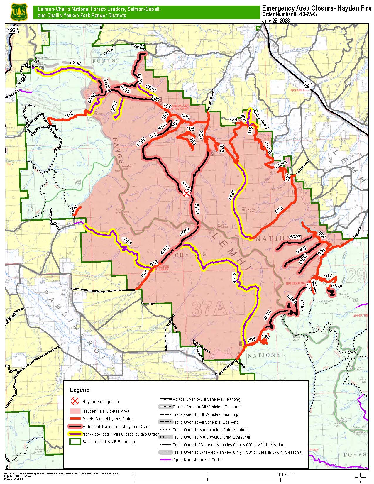
Closure Order 04-13-23-07 Map