
Single Publication
August 11, 2023 Daily Update
Publication Type: Announcement 08/12/2023
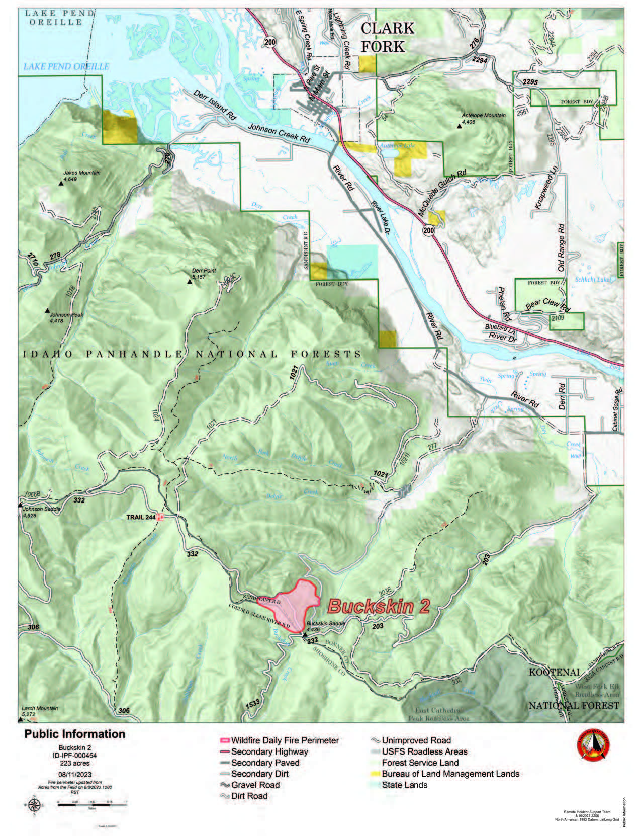
Buckskin 2 Fire
August 11, 2023
Idaho Panhandle National Forests, Sandpoint Ranger District
Fire Information: 208-557-8813
https://inciweb.nwcg.gov/incident-information/idipf-buckskin-2-fire
Type 3 Incident Commander, John Ramsey
Location: Located approximately 8 miles due south of Clark Fork, ID on Delyle Ridge, between Twin Creek and Dry Creek, south of Highway 200
Start Date: 8/4/2023
Cause: Under Investigation
Size: 226 acres (estimated)
Containment: 25%
Total Personnel: 84
Engines:7
Hand Crews: 2
Modules: 3
Heavy Equipment: Dozer
The primary objectives for fire officials managing the Buckskin 2 Fire are firefighter and public safety while working to keep it as small as possible. Yesterday, the fire was active with some single and group tree torching. The fire is estimated at 226 acres, but due to the increase in fires around the nation, an infrared flight to accurately map the fire has not yet occurred. Hand crews are constructing direct lines along the east and west flanks of the fire, while engine crews are continuing structure protection work in the Twin Creek and Rearden Creek drainages, with dozers constructing indirect lines on the north and south side of the fire. The fire remains roughly 1.8 miles from the nearest residence in Twin Creek and Rearden Rd.
EVACUATION STATUS
The Bonner County Sheriff’s Office issued a READY notification for the Twin Creek Rd and Rearden Rd residents in Clark Fork. “Ready, Set, Go” is a program for residents that can help them prepare for an evacuation in case of any emergency and keep them informed about evacuation needs/concerns. To receive local status updates, sign up for Bonner County Sheriff’s Office emergency messaging through NIXLE at www.nixle.com; to learn more about the “Ready, Set, Go” program as well as recommendations on how to be best prepared for wildfire, check out this page from the Idaho Department of Lands.
CLOSURES AND SPECIAL MESSAGES
A Forest Closure Order is officially in effect for roads associated with the Buckskin Fire; the intersection of Forest Service Roads 203 and 332, the intersection of FSR 1021 and 332, and 1533 and 306 in Clark Fork. UTV trail 77 is closed as it goes right into the drainage where the fire is burning. The public is prohibited from the general area for firefighter safety and asked practice caution while driving near firefighters and apparatuses.
It is expected that the FSR 203 closure will be extended to the edge of private land.
Stage II Fire Restrictions went into effect on Wednesday, 8/9. To view the Idaho Fire Restrictions Plan and a statewide map with current information regarding fire restrictions, please visit https://www.idl.idaho.gov/fire-management/fire-restrictions-finder.
A Temporary Flight Restriction is in place for the safety of our aerial resources and firefighters on the ground. This includes drones; please do not fly unmanned aircraft (drones) in the fire vicinity. If you fly, we can't.
WEATHER
Today’s forecast calls mostly sunny, with a steady temperature around 79 and a southwest wind of 8 to 16 mph.